• Grizzly Gulch Maintenance Inventory

    Logan Simpson conducted a Class III cultural resources survey and documentation of 235 acres for the Utah Division of Oil Gas and Mining (UDOGM) in the Grizzly Gulch area of northern Utah. The survey was split between two Areas of Interest (AOIs) and serves as a guide to understand the scale and scope of recording efforts. Logan Simpson recorded all cultural resources encountered to USFS and SHPO standards and prepared NRHP recommendations for identified sites. Due to the extensive historic mining landscape, Logan Simpson recorded each AOI as single, extensive site. The survey resulted in updating two previously recorded sites and one newly recorded site with over 500 historic mining features. The sites contain hard rock mining- and habitation-related features and represent extensive mining landscapes. Logan Simpson also performed re-photography of historic images to compare changes in the built and natural landscapes. A technical report was prepared including NRHP eligibility and AMRP cultural resource management recommendations for all identified cultural resources.

  • Oak Ridge State Wildlife Area Cultural Survey

    Colorado Parks & Wildlife contracted with Logan Simpson to conduct a Class III cultural resources inventories for vegetation thinning to support wildlife management activities at the Oak Ridge State Wildlife Area. The 1,535 acre project area includes 1,015 acres administered by the State of Colorado and 520 acres by the Bureau of Land Management White River Field Office in Rio Blanco County, Colorado. Services may include: prescribed burning of mountain scrub land and aspen habitats; mechanical mulching/thinning of mature mountain scrubs; clearcutting decadent aspen stands to promote regeneration of young aspen trees; interceding diverse custom seed mixes to provide diverse wildlife forage; prescribed burning as follow-up maintenance; and aerial herbicide applications to control weeds and scrub regrowth. The project is considered a federal undertaking subject to compliance with Section 106 of the National Historic Preservation Act. The inventory resulted in the recordation and evaluation of 5 prehistoric and historic sites and 7 prehistoric isolated finds.

  • Navigating Farmington’s Future Comprehensive Plan

    Logan Simpson completed an update to the City of Farmington, New Mexico’s 2002 Comprehensive Plan to reflect the City’s transformation from an economy traditionally reliant on oil, gas, and coal extraction, to one that is much more diverse. Policies within the draft plan highlight an economic future that strengthens key assets such as: outdoor recreation opportunities; a burgeoning film industry; and access to regional healthcare and higher-level education; increased tourism; and becoming an active lifestyle destination for its influx of retirees. The Plan provides recommendations to assist Farmington’s governing bodies in decision-making, moving policy and development forward in a productive way conducive to transforming Farmington into a healthy, sustainable economy. The Plan is reflective of public outreach efforts by integrating what residents and business owners love and the issues they identify. Based on public input, the update includes new elements such as planning for healthy and socially sustainable communities, bicycle and pedestrian infrastructure, and environmental quality.

  • Buckeye Wildlife Corridors, Best Practices Guide

    Logan Simpson developed the first-of-its-kind Wildlife Corridors Best Practices Guide, a set of best management practices and tools for development that considers harmony with wildlife corridors and the natural environment within the City of Buckeye’s growth area. While much of land surrounding the City remains undeveloped and provides essential habitat for wildlife, Buckeye is evolving rapidly, and the population increase warrants thoughtful planning. With the goal of maintaining and enhancing existing biodiversity while ensuring community prosperity, a case study-based approach was taken to organize this Guide around three strands – environmental, growth, and quality of life. The Guide’s is to advocate for wildlife connectivity throughout the City and encourage collaboration between all groups involved in developing Buckeye. Groups and individuals with local expertise helped inform the planning process, including landowners/developers, utilities, local/state agencies, and conservation advocacy groups.

  • Bell Butte Cave and Petroglyph Recording

    In response to possible damages to cultural resources incurred by a City utilities installation project, Logan Simpson completed a joint archaeological and ethnographic study of Bell Butte, which is considered a sacred landmark and confirmed Traditional Cultural Property (TCP) among the Akimel O’Odham (Pima) and Piipaash (Maricopa) communities of southern Arizona. Incorporation of both archaeological and traditional perspectives yielded significant and unprecedented insights into the material and memory culture of the butte. Logan Simpson is presently working with the City to develop land management practices intended to preserve and protect the sacred butte from further desecration, and also advance the repatriation of sacred objects recovered from a cave at the butte to the Akimel O’Odham.

  • Utah Avocational – Identified Rock Imagery


    The Utah State Historic Preservation Office (SHPO) in conjunction with the Utah Rock Art Research Association (URARA) contracted with Logan Simpson in 2020 to conduct targeted archaeological site documentation at rock imagery locations on various land jurisdictions in Carbon, Sanpete, and Sevier Counties in central Utah. Project goals were to obtain baseline information of rock imagery sites to assist with management and interpretive efforts, prepare public products to increase awareness about fragile rock imagery, and incorporate volunteers. Logan Simpson coordinated with SHPO, land managers, and URARA to revisit GPS locations, update/record rock imagery sites to modern standards alongside URARA volunteers, and conduct on-site filming for use in a public video. The result was documentation of 18 newly recorded sites and updates for 53 previously recorded sites. The video features stunning aerial imagery, in-field interviews with archaeologists and volunteers, and centers on themes of preservation, stewardship, and public involvement in cultural resources management.

  • Rio Tinto Kennecott Little Valley Cultural Resource Survey

    Rio Tinto Kennecott Utah Copper, who is a long-term client of Logan Simpson, contracted with us to perform a 75-acre Class III cultural resources survey in the Little Valley Wash. This survey encountered a historic water control system from the late 1930’s, which spanned into the mid 1960’s, and was associated with flash flood control in the Little Valley area. Discoveries included ditches, large-scale masonry spillways, and a retention basin. Mitigation strategies were performed, which included field documentation of the entire water control system, updating the Utah Archaeology Site Form, and preparation of a historic context, which contained historic photographs, newspaper clippings, field photographs, and maps. The results of the literature review and archival research included a history of the region with a focus on the development of flood control structures in Utah, the Soil Conservation Service, and the Works Progress Administration.

  • 8th Street Multiuse Path and Streetscape

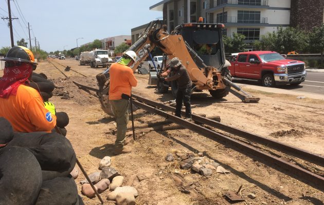
    Logan Simpson assisted the City of Tempe with the Arizona Department of Transportation and Federal Highway Administration in the planning and construction of a mile-long multi-use path and streetscape improvement project along 8th Street. Logan Simpson prepared a survey report for the area of potential effect (APE), including: architectural documentation; National Register of Historic Places eligibility evaluation; Section 4(f) of the Department of Transportation Act assessment; a multi-phased Historic Properties Treatment Plan (HPTP); and an addendum to the HPTP for the railroad prior to conducting archaeological investigations. Phase I investigations included excavating 29 mechanical trenches and one mechanical stripping unit alongside the railroad. The excavations revealed 24 prehistoric features including one human remains, leading to the recommendation for additional Phase II documentation. Consultation with the descendant community upon encountering human remains and a possible platform mound included the recommendation that an ethnographic and oral history component be conducted as part of the Phase II investigations, which are currently underway.

  • BIA Tribal Historic Preservation Office Training

    Throughout the US, State Historic Preservation Officers (SHPOs) assist public agencies with cultural resource preservation and compliance. In 1990, the National Park Service implemented a program through which federally recognized tribes with a reservation or tribal trust lands could establish their own Tribal Historic Preservation Officer (THPO) positions. THPOs can assume SHPO’s responsibilities on tribal lands, advising federal agencies on the management of cultural resources and working to preserve, maintain, and revitalize their unique cultural traditions. Qualifying tribes can take a more direct role in protecting and interpreting the cultural resources on their own tribal lands. A THPO can focus on the culture and landscape they know, making decisions that best serve their tribal community, culture, and history.

    Tribes interested in becoming a THPO are required to submit a written resolution signed by the tribe, a THPO application form, and a program plan to the NPS for review and approval. The program plan describes how the THPO will administer historic preservation functions. Through the work and relationships developed during his tenure as the Bureau of Indian Affairs Western Regional Office archaeologist understood firsthand the incredible benefits available to tribes that attain THPO status, and he wanted to assist other tribes in taking steps to becoming a THPO.  To facilitate the process, The THPO with the Reno-Sparks Indian Colony THPO and the program manager for the NPS THPO program were recruited to conceptualize a workshop to assist tribes with completing their THPO application packets. The BIA called on Logan Simpson, bringing in archaeologists to help develop and organize the workshop. The plan was both ambitious and brilliant.

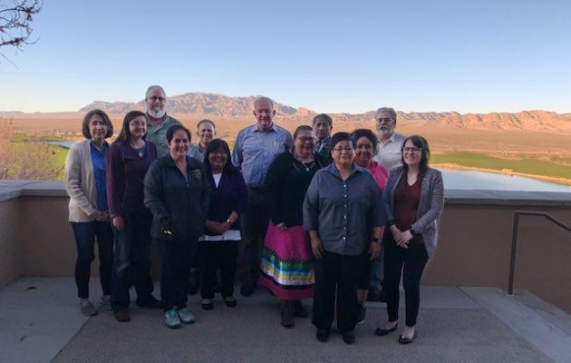
    In March of 2020, this team was able to offer interested tribes a three-day workshop at the Las Vegas Paiute Golf Resort in Nevada, with expenses associated with the workshop covered by the BIA. Four Nevada tribes were able to attend: Confederated Tribes of the Goshute Reservation; Fallon Paiute-Shoshone Tribe; Moapa Band of Paiute Indians; and Walker River Paiute Tribe. The workshop was a tremendous success. The Reno-Sparks Indian Colony THPO lent tremendous insight; the BIA Western Region archaeologist discussed compliance from a federal perspective; and the BIA THPO program manager shared her knowledge of the ins and outs of the THPO application process. Logan Simpson tied all the pieces together. The BIA’s genius was not in putting together a class, per se, but in arranging a supportive environment where tribes could complete their THPO application while attending, getting all the help they needed from experts in the field.

    In the short time since the workshop, the Director of the NPS signed Tribal Historic Preservation Agreements with two of the tribes so that they could assume certain THPO duties on their tribal lands in Nevada. The NPS has now entered into 200 THPO agreements nationwide, which is an exciting milestone for the Tribal Historic Preservation Program. Word of our success in Nevada is spreading and the team is getting calls from other tribes that are interested in participating in the next workshop. Logan Simpson is proud to be a part of this unprecedented effort, and we look forward to showcasing our continued commitment to tribal sovereignty and resource preservation.

  • Sonoqui Wash Phase II Data Recovery


    The Town of Queen Creek requested Logan Simpson complete Phase II archaeological data recovery at site AZ U:14:49 (ASM), a prehistoric Hohokam village site also known as Los Pozos de Sonoqui, which had been determined eligible for listing in the National Register of Historic Places prior to planned construction of the Sonoqui Wash Channelization Project. The overall project’s goal was to develop and implement a plan for channelization of segments of Sonoqui Wash to improve regional flood control. The Phase II project area encompassed approximately 24 acres.

    During the planning stage of the data recovery project, Logan Simpson recommended that the Town consult with affiliated Native American tribes as our staff knew that this site was important to tribal communities. The Town agreed to consult with the tribes, and Logan Simpson included specific questions within the project’s research design in the Historic Properties Treatment Plan (HPTP) that addressed Native American perspectives on water and water management especially given that it was known that a large prehistoric reservoir was present in the project area. In their review of the HPTP, the Gila River Indian Community, Tribal Historic Preservation Office highlighted and praised Logan Simpson’s proposed plan to coordinate tribal outreach with O’odham tribal representatives and elders to obtain O’odham perspectives about the project’s archaeological findings and results.

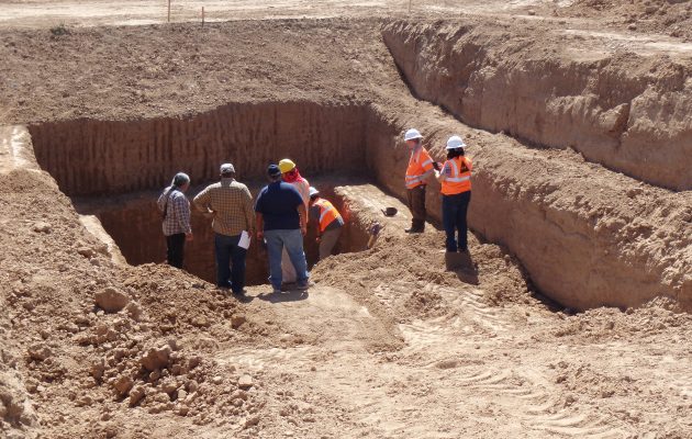
    Prior to conducting fieldwork, crew members received cultural sensitivity training through the Salt River Pima-Maricopa Indian Community to ensure that all crew members understood tribal importance of the resources they would be working to excavate. The excavations resulted in the identification and documentation of 112 features associated with the prehistoric period. One of those features was a massive, centrally located retention basin with an estimated storage capacity of 1,200 cubic meters (317,000 gallons). The reservoir is one of the largest prehistoric reservoirs documented in Arizona. It is an oval-shaped reservoir that measures approximately 38 m by 25 m with a maximum depth of approximately 7.5 m. The reservoir is associated with the late Classic Period portion of Hohokam settlement (A.D. 1375-1450) and demonstrates the inhabitants’ ability to create accessible local water sources by diverting and harvesting runoff into artificial or natural basins. The reservoir underscores the site inhabitants’ ability to successfully harvest rainfall for year-round domestic use. It operated for no more than 50 –60 years and could have supplied domestic water for up to 530 people annually.

    The ethnographic study of contemporary O’odham groups’ traditional water storage technologies, cultural views of water, technical aspects of water harvesting and storage, and related issues in the southern Arizona desert complemented the archaeological work. Logan Simpson engaged Dr. J. Andrew Darling to lead the study, and he interviewed tribal leaders and elders from the Tohono O’odham Nation and the Gila River Indian Community. Furthermore, he brought these tribal members to the excavation site to see the features unearthed by Logan Simpson’s archaeologists.

    This research on O’odham creation stories and water use has elevated archaeologists’ understanding of the persistent connections of affiliated O’odham tribes with the Sonoqui Wash Site and the Queen Creek region. Ethnographic research has also demonstrated the extent, variety, and agricultural flexibility of O’odham communities in the Queen Creek watershed. It contributes to archaeologists’ understanding of the Queen Creek delta as a series of vooshan, shallow alluviated drainages that annually wash over their banks during the summer monsoon, creating broad well-watered areas suitable for farming and water storage. Many vooshan are visible on the Tohono O’Odham reservation today, where fields and villages have been abandoned since the 1950s or earlier.