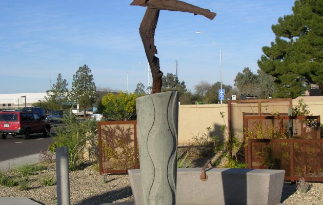
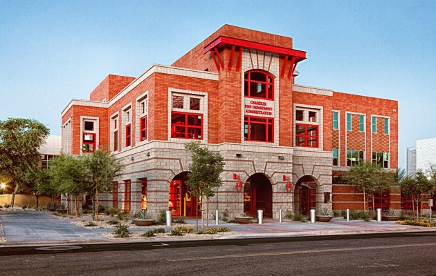
• Chandler Fire Administration Building/Servicemen’s Memorial Plaza

    Logan Simpson’s landscape architecture team developed a comprehensive landscape and hardscape design for this Gold LEED-certified project. Site improvements included staff/visitor parking; a private staff courtyard; and street-front landscaping. The landscape architecture design features a memorial plaza between the fire administration building and the police headquarters. The plaza design merges two circles, symbolizing both departments. Integral colored concrete weaves through the circles toward two memorial sculptures. An arbor shade structure, the backbone of the plaza, helps blend the buildings’ architecture. Circular walls frame the views of the memorials, functioning as buffers and providing private seating. Colorful concrete banding designed within the paving helps to enhance the central focus of the space. A central lawn area softens the hardscape and provides an intimate feel when the plaza is not being used for large events. In addition, to meet CPTED requirements, plants stair-step back toward walls and building foundations to improve visibility. The Memorial Plaza is shared by the Chandler Fire and Police Departments and includes two memorials to the fallen local heroes who lost their lives in the line of duty and those who lost their lives in the World Trade Center attacks.

  • ECO PHX

    ECO PHX is being created to meet an under-served market of environmentally conscientious residents. This purposefully sustainable, infill development of 70 apartment homes that demonstrates what is possible with today’s technology. To accomplish this objective, we approached the design process from the inside out, with sustainability components at the heart of the building’s design. The result is an economically feasible structure integrating sustainable building systems that create a distinctive residential community.


    The project integrates biomimicry by imitating the natural processes of our native Sonoran Desert: Curb cuts will bring in stormwater into the bioswales and provide a dual function of cleaning the water through vegetation as well as supplementing irrigation needs. The green wall mimics Arizona canyons and helps to cool the building. Recycled shower water from the building’s residents provides irrigation, vital in this arid climate.


    ECO PHX sets the standard for future development in Phoenix. The project is being completed for Habitat Metro and the Fenix Capital Group; team members include WERK | urban design, CCBG Architecture, Ritoch Powell, and Sletten Construction.

  • Block 32 Utilities Administration Building

    Located in downtown Fort Collins, Block 32 was an under-utilized parcel with potential to become a vibrant civic campus and public space. Logan Simpson worked with the architect (RNL Design) to develop programming, development concepts, and master planning for the parcel. This vision for the Civic Center is built around sustainable best practices and quality urban design standards. The design team embraced the buildings utilities’ services theme and aspired towards Net Zero classification, coordinating use of solar energy, high efficiency building materials, and low impact design planting strategies. The design incorporates the preservation of a small historic building on site with elements such as rain gardens, a living wall, and utility-themed public art formed into concrete entry walls. Construction on the two-acre Utilities Administration Building site was completed in late 2016. In June 2017, the site was awarded LEEDv4 New Construction (NC) Platinum status, the first V4 NC Platinum project in Colorado, and only the 3rd awarded in the U.S.

  • Scottsdale Airport Gateway – Hayden Road, Cactus to Redfield

    This 1.3-mile roadway segment is a gateway to Scottsdale Airport. As visitors approach the airport, they pass a series of steel “wing” sculptures representing the transition from bird wings to airplane wings. The entry plaza features the stunning sculpture Icarus Falling by Dale Wright. The surrounding hardscape features compass points  in the plaza walls and bollards and constellations used for navigation during flight cast into the ground surface.  The project was recognized by the Arizona Chapter of the American Concrete Institute in 2006 for “Unusual Use of Concrete.”  The plant palette features low-water-use, desert-adapted plants compatible with the neighborhood context. The landscape layout reflects the transition from the urban character south of the project area to the more natural desert that exists north.

  • Standin’ on the Corner Park, Performance Plaza, and Downtown Streetscape

    Thirty years after Interstate 40 bypassed historic Route 66 through Winslow, Arizona, the town took on a project to restore the historic character of its downtown core, which is largely defined by its relationship to the roadway. Improvements included Standin’ on the Corner Park, named for the Eagles song “Take it Easy,” which includes the lyrics “I’m standin’ on the corner in Winslow, Arizona/And such a fine sight to see/It’s a girl, my lord, in a flatbed Ford/Slowin’ down to take a look at me.” Under a Transportation Enhancement grant, Logan Simpson designed the park, an ADA accessible performance stage using historic car front ends as for lighting, a stage cover, and provided theming and streetscape design for the sidewalk trellis, perimeter sidewalk areas, including landscape, accent paving, and street furnishings.

  • Community Wildfire Protection Plans

     The wildland urban interface (WUI) is the area where homes are built near or among lands prone to wildland fire. These areas have become more popular for homeowners for their privacy, natural beauty, recreational opportunities and affordable living. As a result, rural fire districts are more often having to fight fire and protect homes and property within these WUI areas. Logan Simpson developed the first two CWPPs in Arizona for the at-risk communities of the Apache-Sitgreaves National Forest that complied with Title I of the Healthy Forests Restoration Act of 2003 (HFRA). We facilitated the collaboration among Federal, state, and local partners as well as Native American tribes to developed these two CWPPs and established priorities to reduce the risks to communities and surrounding lands. Subsequent to these first two CWPPs, Logan Simpson developed 20 CWPPs, analyzed over 31 million acres, and gathered input from over 300 communities across multiple states.

  • Four Forests Restoration Initiative (4FRI) Facilitation

    The Four Forest Restoration Initiative is a collaborative effort more than 20 years in the making. 4FRI is the flagship of the Forest Service’s national Collaborative Forest Landscape Restoration Program which sought to achieve the collaborative, science-based ecosystem restoration on unhealthy forest landscapes.  This project is considered one of the most massive restoration projects in the nation. Stakeholder collaboration and consensus was central, as the values of restoration are complex. Stakeholders were a broad cross-section of more than 100 organizations, including federal, state, and local government, timber industry, preservation, and environmental interest groups, and citizens. The collaborative had often been divided deeply on specific issues and struggled to achieve consensus. Within four years, the collaborative turned over five different facilitators before turning to Logan Simpson. From 2012 to 2015, Logan Simpson guided the group through several complex challenges. Where possible, we brought electronic polling and modern collaborative planning tools into the 4FRI mix. The group’s success with Logan Simpson included revised decision rules (unanimously adopted); revision of the behavior-related ground rules of the Charter; revisioning/strategic planning each year; consensus comments on a draft EIS for the first analysis area; and successful collaborative leadership leading to broad-based support for the final EIS, which has moved to implementation without litigation. Logan Simpson managed and facilitated the collaborative with steering committee calls, facilitated meetings, problem-solving and conflict resolution.

  • Greater Phoenix Metro Green Infrastructure/LID Handbook

    Low impact development (LID), or sustainable stormwater management, is a green infrastructure (GI) technique practiced widely in the US outside the Southwest. This landscape-based technique can help reduce runoff and stormwater flows in existing conveyance systems, reducing nonpoint source pollutant loads and improving conformance with first-flush requirements. LID reduces stormwater peak flows and volumes, helping mitigating flood hazards. LID can also conserve stormwater, allowing it to be used as a supplemental landscape irrigation source that can help mitigate the heat-island effect and improve quality of life by providing vegetated spaces and shade.

    In Arizona, LID is routinely practiced in Pima County. In recent years, Arizona State University’s Sustainable Cities Network (SCN) has fostered dialogue between Phoenix-area communities and agencies about sustainability, including how GI techniques like LID can be more widely implemented. The result was the Greater Phoenix Metro Green Infrastructure Handbook, which provides 10 LID-based technical standardized details and specifications (TSDSs) in Maricopa Association of Governments format. The 10 details were chosen by the SCN core team (cities of Scottsdale and Phoenix and the Flood Control District of Maricopa County), with input from other local communities.

    Data from more than 4,700 Pima County rainfall events and 319 Maricopa County rain gauges was analyzed to establish storm events where LID techniques can optimally mitigate pollution and flooding. The landscape architect conducted research into the geology and soils of the Phoenix area and developed plant palettes and planting concepts that support the LID approach. The landscape architect also worked closely with the engineer to develop TSDS for each LID feature and provided graphic design.

    The Handbook helps agencies meet water-quality regulations and sustainable design policies. It is the only document available that contains guidance and specific techniques for implementing LID treatments in the Greater Phoenix Metropolitan Area’s unique environment.

  • NPS Transportation Resource Stewardship Protection Tool

    Logan Simpson is beginning Phase IV of this project, which provides a web-based decision-support system to allow NPS staff to manage natural resources within national parks. The tool allows users to aggregate and review natural resource data from multiple parks so trends can be identified. During Phase II, Logan Simpson piloted the program in ten parks in the Southeast Region. During Phase III, we improved the tool based on information gathered from interviews conducted with NPS technical specialists. The pilot testing for this phase was conducted in the Alaska Region and included nine national parks, two national forests, three national wildlife refuges, and BLM’s Eastern Recreational Management Area. In Phase IV, Logan Simpson will update the tool; update/develop support resources; and pilot the tool in the Intermountain Region.

  • City of Cottonwood Historic Resources Inventory and Planning

    At the request of the City of Cottonwood, Logan Simpson performed the first phase of a two-phase historic property inventory and preliminary NRHP eligibility assessment. Phase I included a historic property survey of residential neighborhoods and districts located within the municipal boundaries of the City in an effort to identify those resources that are potentially eligible for inclusion in the NRHP. Phase I results will be incorporated into the City’s municipal planning, land-use, and development processes. Phase II will begin in the winter of 2019, and will include amending the existing Cottonwood NRHP Commercial District boundaries, and updating associated design guidelines for properties located within this NRHP district.