• Duck Valley Architectural Documentation

    Logan Simpson’s historic preservation specialists completed architectural documentation on two buildings located on the Duck Valley Indian Reservation in Owyhee, Nevada. Both buildings, a former hospital and a power house, were constructed in 1937 following the unification of the Shoshone and Paiute Tribes at Duck Valley under the Indian Reorganization Act of 1934. Both the former hospital and power house are constructed of volcanic stone native to the Owyhee area and represent an important period of development in the history of the reservation. Architectural documentation was followed by NRHP eligibility recommendations for each building. Logan Simpson also conducted oral history interviews of two longtime Duck Valley residents to gain more information about each building. These interviews provided valuable material regarding the history of both the former hospital and power house and underscored each building’s significance to the history and development of the Duck Valley Reservation.

  • Hopi Tribe Keams Canyon Quarters Building 36 Historic American Building Survey Documentation

    On behalf of the BIA Western Regional Office, Division of Environmental Management, Logan Simpson completed Historic American Building Survey (HABS)-level documentation for Building No. 36 (H65-01-36). The building was formerly part of the Keams Canyon Boarding School located on the Hopi Indian Reservation in Keams Canyon, Arizona. Architectural documentation included recordation of building materials and construction techniques, as well as large-format black and while film and digital photography, site mapping, and photographic reproduction of floor plans. Documentation was in compliance with federal regulations for Level II HABS documentation submissions to the Library of Congress.

  • National Historic Trail Interpretive Assessments

    The BLM Wyoming State Office is developing conceptual guidelines to improve how BLM manages interpretive sites and overall visitor services along the California, Oregon, Mormon Pioneer, and Pony Express National Historic Trails (NHTs). Most NHT interpretive sites in Wyoming were developed in the 1970s and 1980s and are largely in a state of disrepair. Logan Simpson prepared site concept and interpretive sign plans for 28 BLM historic sites to assist in protecting cultural resources, improving site stewardship and motorized use, and user behavior with appropriate levels of public access. BLM Wyoming’s NHT visitor use and interpretive guidelines report will improve outdated facilities, accessibility, brand conformity, and interpretive effectiveness. The research and guidance on visitor profiles and outcomes, and shared goals with external partners will assist with visitor use planning. BLM Guidelines for the Quality Built Environment were implemented for the 28 sites, which in combination with an inventory and project record will streamline preparation of subsequent NEPA compliance.


    For the first time in the history of the National Trails System Act, a statewide and trail-wide Recreation Opportunity Spectrum (ROS) inventory characterizes the physical, social and operational components of Wyoming’s NHT visitor services. The ROS inventory of specific recreational setting characteristics and desired experiences is based on cultural resource sensitivity and public lands access and will inform subsequent resource management plans and NEPA analyses. An “idea book” was also prepared to highlight innovative interpretive methods not being utilized by BLM to inform detailed design of interpretive signage and digital mediums.

  • BLM Worland Field Office Travel Route Inventory

    Logan Simpson conducted route inventories of 3,429 miles and captured over 9,000 geotagged photos across 1,710,089 acres in the Worland Field Office in Wyoming. We used BLM’s GTLF standard in conjunction with a customized data dictionary. The inventory team maintained photos and track logs to document conditions and location of infrastructure such as campsites, signs, gates, unexpected trail terminations, etc. Inventory crews camped on BLM land during the inventory to avoid daily commuting, resulting in higher (inventoried) miles per day. This approach allowed the team to complete the project on budget and within the period of performance. Special consideration was given to the season in which inventory was conducted to ensure an accurate travel network was documented. Conducting the inventory around hunting season resulted in the documentation of routes that only have heavy use during that time of year.

  • Little Snake Route Evaluation, Travel Management Plan, and EA

    The BLM Little Snake Field Office route evaluation and travel management plan (TMP) is creating a new model for controversial transportation plans. Logan Simpson conducted evaluation, NEPA, and travel management planning tasks, including an EA, for 800 miles of roads, highways, and trails in the Hiawatha, Sand Wash, and Bears Ears travel planning areas in northwestern Colorado. The goal of the TMP is to create a travel network that is logical and sustainable, and also meets the increasingly diverse transportation, access, and recreational needs of the public. The EA analyzes the proposed plan and the alternatives that were considered during the planning process. Resources in the planning area include wildlife, cultural resources, grazing, energy and minerals, rights-of-way, paleontological resources, and recreation. We used Logan Simpson’s Travel Resource Analysis Model (TRAM) evaluation tool, which builds on the fundamental requirements set in the resource management plan to identify the benefits and risks associated with each route. TRAM allows NEPA data and guidance to be viewed in real time and creates an automatic administrative record of project details.


    We also used unconventional public involvement activities to engage stakeholders and cooperating agencies early in the planning process. We conducted public open houses inviting the public to engage early in the review of inventoried routes, evaluation criteria for route evaluation, identification of scoping issues, and review of proposed alternatives. We also used an online commenting tool allowing the public to comment on individual routes in addition to general comments on the travel system.


    Logan Simpson is following the streamlining guidelines contained in the Secretary of the Interior’s Executive Order 3355 as we develop the EA.

  • Arkansas Headwaters Recreation Area Management Plan Revision and EA

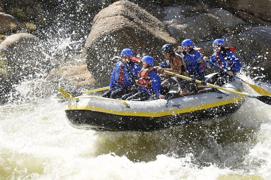
    Logan Simpson worked with the BLM (NEPA lead); Colorado Parks and Wildlife (management plan lead); and the US Forest Service (land manager) to update to the management plan and EA for the 150 miles Arkansas Headwaters Recreation Area (AHRA).  The AHRA is one of the nation’s most popular whitewater boating rivers and receives the highest level of commercial boating of any river in the nation. With 700,000 visitors annually, the AHRA is also popular for camping, wildlife watching, gold panning, and numerous other river-related recreation activities including its Gold Medal Trout Fishery. The challenge for the AHRA is to satisfy seemingly infinite recreational demands while at the same time maintaining both the environmental quality and the quality of visitor experiences along the river. The issue-driven management plan and EA addresses a wide array of topics, with a focus on carrying capacity, potential user conflicts, special activity and special use permitting, travel management updates for key areas, the need for new or improved facilities, and improved access and resource conservation. Logan Simpson led three rounds of public outreach to help guide the AHRA partnership in four different cities across the Front Range and in the project vicinity.

  • BLM Johnson Hill Special Recreation Area Travel Management Inventory

    Logan Simpson completed 220 miles (7,647 acres) of route inventory within the BLM’s Socorro Field Office in New Mexico. The inventoried area included the Johnson Hill (Gordy’s Hill) Special Recreation Management Area and the Quebradas Backcountry Byway. Logan Simpson used the BLM’s GTLF standard in conjunction with a customized data dictionary. The inventory team captured over 1,000 geotagged photos to document route conditions and the location of infrastructure such as stock tanks, cattle grates, campsites, signs, gates, and other features in a landscape that contained very variable terrain that includes deep canyons, sand washes, high sandstone and limestone bluffs, terraces, and escarpments. The Johnson Hill Special Recreation Area is a popular OHV destination with challenging features and our inventory team was able to accomplish the work efficiently and safely. The BLM will use the GIS data and photos collected during the inventory as part of travel management planning.

  • BLM Lander Field Office Travel Management Inventory

    Logan Simpson conducted a route inventory of 5,259 miles for the Lander Field Office within the Agate Flats, Antelope Hills and Crooks Mountain Travel Management Areas in Wyoming. The project, which consists of 1,449,305 acres, was awarded under Logan Simpson’s BLM Travel Management BPA. The team used the BLM’s GTLF standard in conjunction with a customized data dictionary that included unique attributes requested by the field office, such as dominant vegetation type, noxious weed presence and the potential for off-track travel. The inventory team captured thousands of geotagged photos and photo points with over 70 domain choices for features such as route drainage, barrier or hazard, facility, resource, recreation use, and more to document route conditions and the location of infrastructure and other features of interest. The vast inventory area (roughly equivalent to the size of the state of Delaware) for this project was very remote and contained five wilderness study areas. To improve efficiency and minimize commute time our inventory team camped on site and moved our base camp as progress was made. This project received exceptional ratings from the agency in quality, schedule, cost control, management, and regulatory compliance.

  • Fruita Downtown Streetscape Improvements

    Logan Simpson developed design enhancements to the City of Fruita, Colorado’s historic downtown core. The enhancements support business growth, will spur infill and redevelopment, and support the continued growth of festivals and events that are important economic stimuli for the community. The town is at the northern gateway to Colorado National Monument, and is well known for its scenic mountain-biking trails, Dinosaur Museum, and annual “Mike the Headless Chicken” and “Fat Tire” festivals. The Logan Simpson team prepared a master plan for Civic Center Memorial Park, which anchors the east end of the historic downtown, and hosts up to 25 concerts and community events during the year. We also developed plans for downtown core streetscapes, which accommodate year-round circulation and activities, as well as closures for major festivals. In the center of downtown is Park Square, which is currently dominated by cars and expansive asphalt paving associated with a large roundabout that surrounds Circle Park. The plan recommends widening the sidewalks around the square to 16 feet, and creating “woonerfs,” or living streets, in the corners that have landscaping and new pedestrian use areas that can accommodate buskers, vendors, food carts, and other temporary uses.

  • Big Thompson River Restoration Master Plan

    Logan Simpson developed a post-flood river restoration master plan along an 80-mile corridor. The plan was designed to improve the flood resilience of infrastructure and to restore the river corridor after the massive destruction caused by the flooding of September 2013. Logan Simpson led an extensive stakeholder and multiagency engagement program, and focused on small group discussions using large-format maps of the affected area, website information, interagency meetings, elected and appointed official briefings, and on online map commenting tool called sMap. The lead engineering firm conducted geomorphic and flood risk assessments; ecological habitat assessments; reach prioritization; and developed recommendations that Logan Simpson illustrated in prototypical plans and sections. Logan Simpson went on to prepare “A Bigger Vision for the Big T,” a restoration and conservation plan for restoring and enhancing public recreational opportunities and conserving lands along the river corridor. The plan was designed to prioritize strategic investment, coordinate funding strategies, and facilitate unified decision-making among stakeholders.