• BIA Tribal Historic Preservation Office Training

    Throughout the US, State Historic Preservation Officers (SHPOs) assist public agencies with cultural resource preservation and compliance. In 1990, the National Park Service implemented a program through which federally recognized tribes with a reservation or tribal trust lands could establish their own Tribal Historic Preservation Officer (THPO) positions. THPOs can assume SHPO’s responsibilities on tribal lands, advising federal agencies on the management of cultural resources and working to preserve, maintain, and revitalize their unique cultural traditions. Qualifying tribes can take a more direct role in protecting and interpreting the cultural resources on their own tribal lands. A THPO can focus on the culture and landscape they know, making decisions that best serve their tribal community, culture, and history.

    Tribes interested in becoming a THPO are required to submit a written resolution signed by the tribe, a THPO application form, and a program plan to the NPS for review and approval. The program plan describes how the THPO will administer historic preservation functions. Through the work and relationships developed during his tenure as the Bureau of Indian Affairs Western Regional Office archaeologist understood firsthand the incredible benefits available to tribes that attain THPO status, and he wanted to assist other tribes in taking steps to becoming a THPO.  To facilitate the process, The THPO with the Reno-Sparks Indian Colony THPO and the program manager for the NPS THPO program were recruited to conceptualize a workshop to assist tribes with completing their THPO application packets. The BIA called on Logan Simpson, bringing in archaeologists to help develop and organize the workshop. The plan was both ambitious and brilliant.

    In March of 2020, this team was able to offer interested tribes a three-day workshop at the Las Vegas Paiute Golf Resort in Nevada, with expenses associated with the workshop covered by the BIA. Four Nevada tribes were able to attend: Confederated Tribes of the Goshute Reservation; Fallon Paiute-Shoshone Tribe; Moapa Band of Paiute Indians; and Walker River Paiute Tribe. The workshop was a tremendous success. The Reno-Sparks Indian Colony THPO lent tremendous insight; the BIA Western Region archaeologist discussed compliance from a federal perspective; and the BIA THPO program manager shared her knowledge of the ins and outs of the THPO application process. Logan Simpson tied all the pieces together. The BIA’s genius was not in putting together a class, per se, but in arranging a supportive environment where tribes could complete their THPO application while attending, getting all the help they needed from experts in the field.

    In the short time since the workshop, the Director of the NPS signed Tribal Historic Preservation Agreements with two of the tribes so that they could assume certain THPO duties on their tribal lands in Nevada. The NPS has now entered into 200 THPO agreements nationwide, which is an exciting milestone for the Tribal Historic Preservation Program. Word of our success in Nevada is spreading and the team is getting calls from other tribes that are interested in participating in the next workshop. Logan Simpson is proud to be a part of this unprecedented effort, and we look forward to showcasing our continued commitment to tribal sovereignty and resource preservation.

  • Teton View Regional Plan for Sustainable Development

    Residents in the rural, diverse landscape of Teton region rely on regional resources for employment, recreation, and housing—making a regional plan for sustainability and resiliency a necessity. Working together, four counties in Wyoming and Idaho created the Teton View Regional Plan for Sustainable Development. The plan highlights what the region shares in common while respecting the varied economic, political, and cultural views of each community. It presents a voluntary “livability roadmap” to guide each jurisdiction in its future development. The plan outlines parallel paths that each locality may travel independently or through coordinated, region-wide implementation. It outlines high-priority community-scale projects and multi-sector initiatives to be led voluntarily by local cities, counties, and organizations. Additional projects are summarized that may be implemented by localities over the long term. The plan’s regional approach is designed to help city and county officials, and public land managers better coordinate land-use planning, resource management, and community development efforts for the region’s long-term benefit.

    The Teton View Regional Plan for Sustainable Development earned Idaho Smart Growth’s 2016 Planning & Policy Award and the 2015 Gem Award from the Idaho Chapter of the American Planning Association.

  • West Central Mountains Economic Development Strategy

    Logan Simpson’s community planning team helped communities throughout Idaho’s West Central Mountains Region build the West Central Mountains Economic Development Strategy (WCMEDS), a plan for economic resilience. Just 10,800 residents live in the 3 million-acre region. Over the past 40 years, the area’s economy has changed dramatically. WCMEDS contains short- and long-term goals that address six elements affecting the region’s quality of life and economic future. The strategy identified five key industries for which the region is well-positioned. An adaptive management program with associated metrics allows the region’s communities to  check progress against goals.

    There has been consistent progress against the plan since its adoption, demonstrating the strong spirit of collaboration between the region’s communities. A regional economic summit has taken place; a housing trust has been established; development of a parks and recreation district is underway; and an area sector analysis project are reaching the point of completion. The group has effectively enhanced youth activities and formed partnerships to address veterans’ needs. Progress is also being made in other areas, such as workforce development, construction of bus kiosks, update of the Valley County Pathways Master Concept Plan, establishing business incubators, construction of community gardens, and forest preservation. Implementation of the plan was partially funded by two grants awarded through the America’s Best Communities (ABC) competition. The plan won the 2016 American Planning Association Vernon Deines Merit Award for an Outstanding Small Town Special Project Plan and the 2016 American Planning Association Idaho Chapter Outstanding Plan Award. Read the plan here or watch a video here.

  • Browns Canyon National Monument Resource Management Plan and EIS

    Logan Simpson led preparation of the first-ever resource management plan (RMP) for the newly-created Browns Canyon National Monument in Colorado. This 21,604-acre monument is located along the upper Arkansas River and contains scenic and diverse natural resources. The monument is jointly managed by BLM and USFS and includes one of the most heavily utilized commercial boating areas in the nation. The RMP focuses on protection of resources, continued public use and enjoyment, and continuation of historic uses, such as livestock grazing.

    Logan Simpson also prepared the associated EIS for the BLM and USFS. The EIS was completed in just 434 days from the Notice of Intent to the publication of the Record of Decision in July 2020—more than a year ahead of the contracted schedule.  Logan Simpson’s planners employed multiple strategies to help keep the project moving, such as crosswalking the agencies’ vocabularies and processes. This small but important step helped improve the Interdisciplinary Team’s respect and understanding for each agency’s guidelines and reduced schedule delays and do-overs.

  • Chandler Fire Administration Building/Servicemen’s Memorial Plaza

    Logan Simpson’s landscape architecture team developed a comprehensive landscape and hardscape design for this Gold LEED-certified project. Site improvements included staff/visitor parking; a private staff courtyard; and street-front landscaping. The landscape architecture design features a memorial plaza between the fire administration building and the police headquarters. The plaza design merges two circles, symbolizing both departments. Integral colored concrete weaves through the circles toward two memorial sculptures. An arbor shade structure, the backbone of the plaza, helps blend the buildings’ architecture. Circular walls frame the views of the memorials, functioning as buffers and providing private seating. Colorful concrete banding designed within the paving helps to enhance the central focus of the space. A central lawn area softens the hardscape and provides an intimate feel when the plaza is not being used for large events. In addition, to meet CPTED requirements, plants stair-step back toward walls and building foundations to improve visibility. The Memorial Plaza is shared by the Chandler Fire and Police Departments and includes two memorials to the fallen local heroes who lost their lives in the line of duty and those who lost their lives in the World Trade Center attacks.

  • CSU Football Practice Facility and Heritage Garden

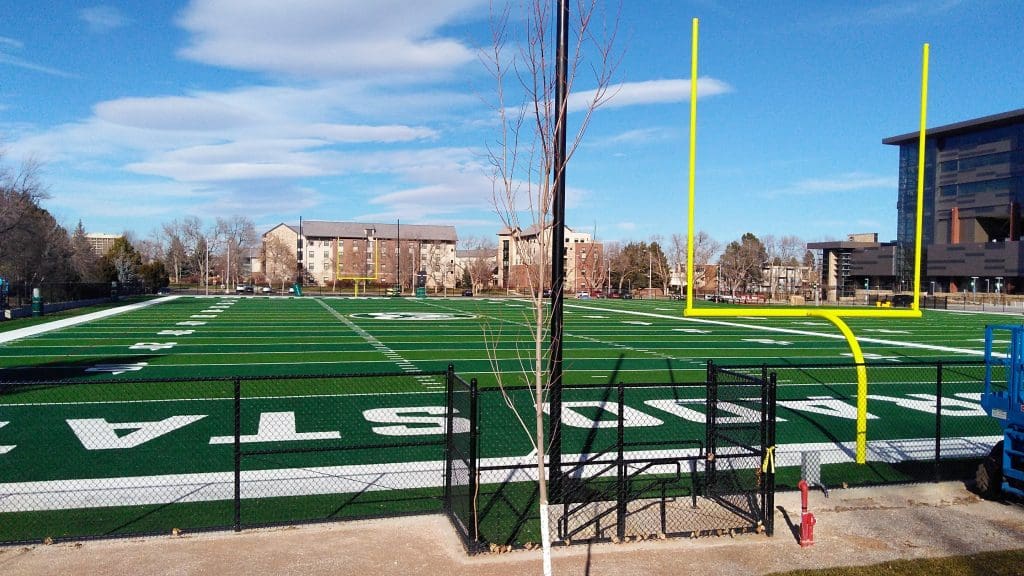
    Logan Simpson led the design of a football practice facility and a heritage garden adjacent to Colorado State University’s football stadium. The 2.6-acre facility contains a full-size field, a partial-length field, and specialty training equipment. The 0.7-acre Heritage Garden incorporates a decorative arbor and plantings from CSU’s six agricultural research stations to represent the university’s agricultural heritage. Logan Simpson’s landscape architects worked closely with CSU to understand the narrative the university wanted to convey. We added an interpretive plaza and improved an existing arboretum by adding outdoor classroom space and a collection of native and naturalized plant species. The Heritage Garden was completed prior to the opening of the new stadium, and now welcomes visitors to campus as they make their way to games and stadium events.

  • Roundhouse Renewable Energy Project

    The Roundhouse Renewable Energy Project included: a Class I literature Review, Class III archaeological survey, mitigation/excavation of a multi-component site, leading cultural resources training for construction personnel, and conducting archaeological monitoring during construction. The linear transmission line consisted of 28 miles of cultural survey that included full documentation of previously recorded and newly recorded archaeological sites within the project area and providing recommendation of their eligibility to the National Register of Historic Places (NRHP). A full Class III survey report was prepared for submittal to the State Historic Preservation Office.

    The survey area encompasses a variety of prehistoric and historic sites. Prehistoric sites included lithic scatters and habitation sites, while historic sites included mining complexes, sheep ranches, and homesteads. After the completion of the cultural survey, the Logan Simpson project manager developed an avoidance and testing plan for nine NRHP-eligible sites in advance of the construction of the transmission line towers. The testing plan included a variety of mitigation techniques including avoidance fencing, monitoring, trenching, test units, diagnostic surface collection and shovel testing. Site mitigation included systematic mechanical trenching, unit excavation and controlled surface collections. Laboratory analysis and curation took place at Colorado State University. The mitigation report is nearing completion, and Logan Simpson provided an archaeological monitor for the project to ensure that NRHP-eligible sites are not disturbed during construction.

  • Montrose City-Wide Historic Resources Survey Plan

    Logan Simpson recently completed a city-wide historic resources survey plan for the City of Montrose, Colorado. The project was funded by a certified local government (CLG) grant provided by the Colorado State Historic Fund and established baseline data and priorities to help guide the wise use of the community’s resources. The creation of this historic resources survey plan overlaps with Montrose’s ongoing efforts to update its 2008 Comprehensive Plan, which will act as the official guide for the city’s strategic planning up to the year 2040. Logan Simpson’s survey plan includes evaluation of existing data, historic context development, limited reconnaissance level survey, descriptions of significant resources and property types, and public outreach. Through these efforts, Logan Simpson identified multiple historic resources for individual and district designations, documented the presence of significant landscapes, streetscapes, viewsheds, and historic and vintage signage, and identified over 25 different architectural styles and forms within City limits. The report also includes a discussion of goals, objectives, and a list of historic preservation priorities ranked in order of importance to be implemented over the next 15 years.

  • Larimer County Comprehensive Plan and Mountain Resilience Plan

    No community is immune from the impacts of significant disruptions, and it is impossible to anticipate and prepare for all possible natural or economic hazard events. Larimer County’s new Comprehensive Plan helps build individual and community self-sufficiency in the event of a disaster, as well as strengthening the capacity of the county to continue supplying critical goods and services during emergency situations and throughout recovery.

    Larimer County is diverse—demographically, economically and geographically. More than half of the County’s 2,634 square miles is sparsely populated mountainous terrain, while the Front Range area encompasses one of the fastest growing urban areas in Colorado. Larimer County recognized the areas’ different challenges, and elected to develop the new comprehensive plan into two phases, each of which address the needs of the mountain and Front Range communities separately.

    The Comprehensive Plan holistically structured the format, process, and content around six resiliency frameworks: community, economy, health & social, housing, infrastructure, and watersheds & natural resources. Public involvement was key to the Plan’s success, and the plan was refined through in-person conversations at 13 community events, 830 online survey responses, 46 one-on-one interviews, and over 25 regular workshops with the three project committees and county leaders.

    The Plan in Action

    An unexpected and favorable result of the two-phase approach was early implementation and actions even ahead of adoption of the full Comprehensive Plan. The Framework Map geographically illustrates the policies reflected in the plan, including subarea planning and targeted rural development. Other notable achievements since plan adoption include the current update of the County Land Use Code to reflect the community’s vision and moving forward on establishing a process and prioritization criteria for subarea planning for unincorporated communities.

    The Comprehensive Plan called for expansion of broadband service into digitally isolated rural areas, as well as the expansion of the Larimer Connects program—a county program created with the understanding that communities that do not have good social connectivity and access to resources are not able to fulfill their potential in becoming resilient. These programs are already proving to be essential to managing the impacts of the COVID-19 pandemic on rural residents.

    The Larimer County Comprehensive Plan and Mountain Resilience Plan won the 2020 Community Resiliency Honor Award from the Colorado Chapter of the American Planning Association. Read the plan here. 

  • Green Mountain Falls Comprehensive Plan & Hazard Resiliency


    Logan Simpson worked with the Town of Green Mountain Falls to update their Comprehensive Plan. GMF is a small mountainous community challenged by the recession, wildfires, small landslides, and flooding. Still the community maintains successful businesses and public amenities, due in large part to a supportive community of committed residents and volunteers and a unique town character and extensive trails system that draws visitors from near and far. This plan recommended tailored and actionable direction based on key issues and opportunities. It established a basis for future Town policies and priorities for development and will provide a balanced, predictable, and flexible land use plan and implementable strategies for housing affordability, hazard mitigation and resilience, infrastructure upgrades, and general improvements for community services and character. In regards to resiliency, the plan analyzed wildfire and its effect on this wildland-urban interface community. Land use policies to protect critical human infrastructure, municipal water and power supplies, evacuation routes, and major recreation areas and transportation corridors were then developed. The plan was unanimously adopted in July 2019. Read it here.