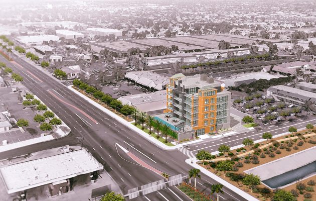
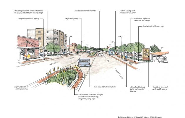
• Scottsdale Airport Gateway – Hayden Road, Cactus to Redfield

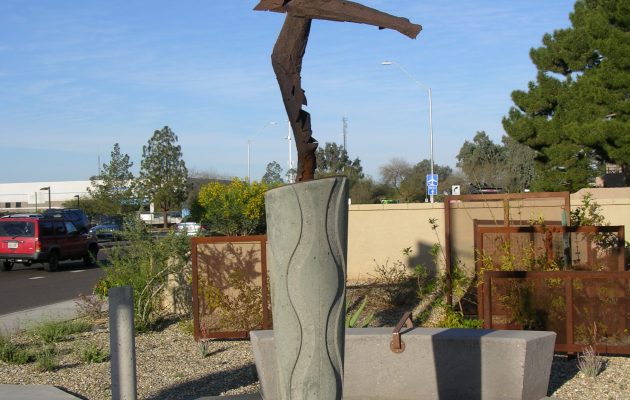
    This 1.3-mile roadway segment is a gateway to Scottsdale Airport. As visitors approach the airport, they pass a series of steel “wing” sculptures representing the transition from bird wings to airplane wings. The entry plaza features the stunning sculpture Icarus Falling by Dale Wright. The surrounding hardscape features compass points  in the plaza walls and bollards and constellations used for navigation during flight cast into the ground surface.  The project was recognized by the Arizona Chapter of the American Concrete Institute in 2006 for “Unusual Use of Concrete.”  The plant palette features low-water-use, desert-adapted plants compatible with the neighborhood context. The landscape layout reflects the transition from the urban character south of the project area to the more natural desert that exists north.

  • Lincoln Corridor Plan

    Logan Simpson developed a vision plan for the Lincoln Avenue corridor extending from Old Town Fort Collins, Colorado to Lemay Avenue. The area contains a rich, eclectic mix of industry, breweries, historic neighborhoods, access to the Poudre River, open space, and regional trail systems. Woodward Governor recently chose the corridor for their new 6,000-employee world headquarters, in part because Lincoln Avenue would consist of a unique street design.

    As an emerging district adjacent to Old Town, Lincoln is envisioned as one of the next great places in Fort Collins. The Lincoln Corridor Plan provided specific recommendations on extensive street and bridge enhancements; incorporates best practices for street design including bioswales and permeable pavements; provides multimodal access; includes pedestrian amenities and gathering areas; establishes a cohesive identity for the corridor; recommends implementation strategies for funding and phasing; and prioritizes improvement projects.

    The vibrant street design sets the stage for a mix of small- and large-scale development. Neighboring residents and businesses provided extensive input on the vision through multiple online surveys, project webpage, bilingual project materials, a series of informational events such as barbecues, highly interactive workshops, attendance at local fairs and events, and corridor walks with residents, business owners, and other stakeholders.

  • Mesa Southwest Redevelopment Area Plan

    After completing a finding of necessity and a determination of blight study to establish the Southwest Redevelopment Area, the Logan Simpson team led the development of an overall vision and redevelopment plan for the declining Fiesta District. This plan will serve as the blueprint for redevelopment activities and opportunities in the area, with the primary catalyst being the re-imagination and redevelopment of an outdated and underutilized regional shopping mall into an employment center and building off adjacent activity of the Banner Hospital and Mesa Community College. The plan outlines a vision for two subareas, defining strategies, associated potential projects, order of magnitude costs, potential partnerships, and timeframes that will ultimately transform the district and adjacent corridors into a vibrant employment district. Key strategies and actions include the improvement of gateways from US 60; streetscape design, improvements, and enhanced street frontages along Country Club Boulevard; five key catalyst site design frameworks and visualizations; and enhanced access into surrounding residential neighborhood areas. Read the plan here. 

  • Highway 287 Strategic Plan

    Logan Simpson worked with the City of Loveland, Colorado to develop a strategic plan for US Highway 287, a regional highway that is the predominant north/south route through the city. The plan provides both policy and physical improvement recommendations, with a focus on revitalization and economic vitality of the corridor for the next 20 years. Key objectives of the plan include creating a positive, welcome image along the corridor; generating private investment; facilitating the redevelopment of deteriorated areas; increasing jobs and generating new tax revenue through development; creating a gateway corridor to downtown Loveland; improving public infrastructure along the corridor; and defining and implementation strategy and providing specific recommendations for City Council action.

    A key component of the plan was the identification of key catalyst sites along the corridor. Conceptual bird’s eye perspective sketches of these catalyst projects were developed, providing city leaders an exciting vision for how these sites could transition over time, attract private investment, and improve the overall image and character of the corridor. A market study identified economic opportunities along the corridor, and informed the development of the catalyst sites. Public outreach included case study investigations, public open houses, business owner forums, and monthly meetings with an advisory committee made up of interested business owners and citizens.

    Read Part 1 of the plan here.
    Read Part 2 of the plan here.

  • Erie Parkway Corridor Study

    Logan Simpson helped develop a vision plan and streetscape design guidelines for the six-mile Erie Parkway corridor in Erie, Colorado. The area contains a diverse mixture of districts including downtown, existing and proposed residential areas, community and regional commercial areas, and a crossing of the Coal Creek open space and regional trail.

    The corridor plan is meant to identify—and eventually implement—multimodal transportation and streetscape improvements to enhance mobility, safety, and aesthetics along the corridor. The streetscape design was tailored for each character district, which provides variety while maintaining consistency between the elements and reinforcing and enhancing Erie’s small town identity.

  • Handbooks, Manuals, and Field Guides

    Logan Simpson has developed many manuals related to planning, design, construction, and maintenance of public facilities. We have also developed a variety of other technical, procedural, and program guidance documents, such as best management practices, field guides, decision-support tools, and training curricula. Our in-house staff includes technical writers and editors, graphic designers, and document development specialists who work with our landscape architects and other professional staff to translate complex technical requirements into easy-to-understand text. Depending on our client’s direction, we have produced detailed “cookbook”-style manuals that prescribe specific actions; guidance manuals that mix narrative with instructive graphics and images; and even manuals that rely heavily on interactive graphics as the primary gateway to the information the manual contains.

  • Tempe Streetcar

    Logan Simpson was the lead urban designer and landscape architect for this high-profile alternative transportation project in Tempe, Arizona that is being developed on an accelerated timeline to accommodate federal funding requirements. The  project includes 14 stops in both a center two-way and side one-way loop. The streetcar will serve the historic Mill Avenue retail district, Arizona State University’s main campus, Tempe Town Lake’s Marina Heights redevelopment, and the rapidly growing new and historic residential neighborhoods south of downtown. The primary goal of this federally funded urban transportation project, is to surgically integrate the streetcar into the existing urban fabric minimizing its impact on an already vibrant streetscape. Services included stop and platform design, landscape and irrigation design, site planning for transit support facilities, and architectural and wayfinding and interpretive signage services. The design followed urban design guidelines developed by Valley Metro and the City of Tempe to seamlessly fit the streetcar into the existing historic downtown and surrounding neighborhood character areas. Project goals include providing intuitive and barrier-free access to stops, incorporating sufficient shade, lighting and seating in waiting areas, and integrating public art into each of the stops.  The project adheres strictly to ADA, PROWAG, and CPTED standards.  The $186 million project was funded with regional Proposition 400 funds, local funds, and federal grant funds.

  • Erosion Control/Clean Water Act Training

    As Arizona environmental consultants, Logan Simpson delivers statewide erosion control training on behalf of the Arizona and Nevada Departments of Transportation in conjunction with the Arizona and Nevada chapters of the Associated General Contractors. Training allows individuals to become credentialed to conduct erosion control activities on behalf of the agency. Curriculum includes CWA regulations; permitting; inspection; construction site controls and practices; creation/upkeep of permit-required documents such as stormwater pollution prevention plans and monitoring plans; and conditions of CWA permits. Logan Simpson developed the curriculum, teaching materials, tests, and handouts and delivered the training for both agencies. Successful completion of the Arizona training allows construction companies and individuals to be certified as erosion control coordinators for ADOT projects. Successful completion of the Nevada training certifies individuals as water pollution control managers on NDOT projects.

  • SR 347/Union Pacific Railroad Overpass EA

    Logan Simpson’s Arizona environmental planning team prepared an environmental assessment for a grade-separated crossing over the Union Pacific Railroad. SR 347 is a north-south roadway that crosses the Union Pacific Railroad in the center of the City of Maricopa. When trains pass through the city, traffic on SR 347 is stopped. The nearest alternative crossings require several miles of out-of-direction travel to reach. About 34,000 vehicles a day using SR 347 compete with the 60 trains a day traveling the Union Pacific. With growth in the area anticipated to continue, resolving congestion and train-caused traffic delays has become a high priority for the City of Maricopa, the Arizona Department of Transportation, and regional transportation officials. Ten build alternatives were evaluated and a preferred alternative was selected. The Arizona environmental planning project will require the acquisition of several properties, the relocation of the existing Amtrak station, and will include local roadway realignments and modifications. The project involved extensive public outreach meetings and continual agency coordination. The primary concerns raised by the community centered around the potential acquisition and access impacts to businesses, rerouting traffic to roads that are already congested particularly during peak hours, increased noise levels, the effects to community facilities, and the project’s accommodation of bicyclists and pedestrians.

  • West Highway 192 Redevelopment Plan

    Osceola County, Florida’s goal is to grow and diversify the county’s economy by making the 15-mile US 192 corridor more attractive to viable businesses. National community planning firm Logan Simpson completed a parcel-by-parcel analysis and a master planning effort for the W192 corridor, encompassing 4.3 miles extending west from Walt Disney World. The purpose of this planning effort is to identify programs and projects that can enhance the area’s appeal to the leisure tourism market and attract new investments. The planning effort is designed as a community-based initiative with continuing opportunities throughout the planning process for the core area’s property and business owners to provide policy direction. It will focus on what actions best strengthen the segment’s economic position and, ultimately, offer a vision and supporting development activities that have been selected through a public participation process. Read the W192 Redevelopment Plan here and the Design Guidelines Reference Guide here.