• Lincoln Corridor Plan

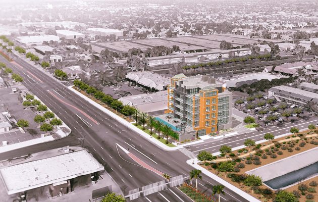
    Logan Simpson developed a vision plan for the Lincoln Avenue corridor extending from Old Town Fort Collins, Colorado to Lemay Avenue. The area contains a rich, eclectic mix of industry, breweries, historic neighborhoods, access to the Poudre River, open space, and regional trail systems. Woodward Governor recently chose the corridor for their new 6,000-employee world headquarters, in part because Lincoln Avenue would consist of a unique street design.

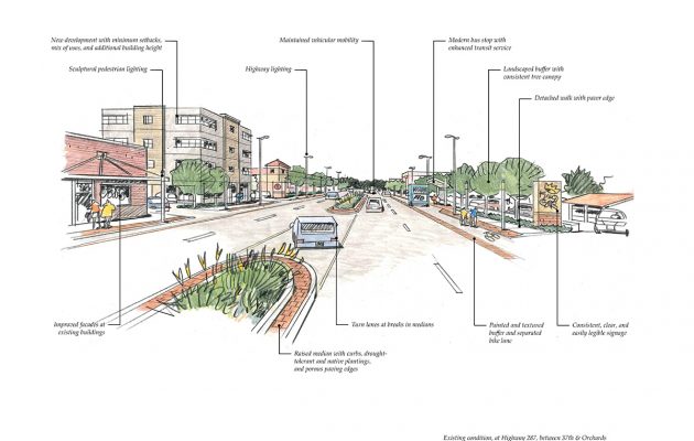
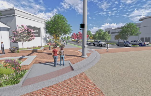
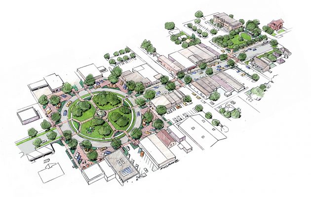
    As an emerging district adjacent to Old Town, Lincoln is envisioned as one of the next great places in Fort Collins. The Lincoln Corridor Plan provided specific recommendations on extensive street and bridge enhancements; incorporates best practices for street design including bioswales and permeable pavements; provides multimodal access; includes pedestrian amenities and gathering areas; establishes a cohesive identity for the corridor; recommends implementation strategies for funding and phasing; and prioritizes improvement projects.

    The vibrant street design sets the stage for a mix of small- and large-scale development. Neighboring residents and businesses provided extensive input on the vision through multiple online surveys, project webpage, bilingual project materials, a series of informational events such as barbecues, highly interactive workshops, attendance at local fairs and events, and corridor walks with residents, business owners, and other stakeholders.

  • Mesa Southwest Redevelopment Area Plan

    After completing a finding of necessity and a determination of blight study to establish the Southwest Redevelopment Area, the Logan Simpson team led the development of an overall vision and redevelopment plan for the declining Fiesta District. This plan will serve as the blueprint for redevelopment activities and opportunities in the area, with the primary catalyst being the re-imagination and redevelopment of an outdated and underutilized regional shopping mall into an employment center and building off adjacent activity of the Banner Hospital and Mesa Community College. The plan outlines a vision for two subareas, defining strategies, associated potential projects, order of magnitude costs, potential partnerships, and timeframes that will ultimately transform the district and adjacent corridors into a vibrant employment district. Key strategies and actions include the improvement of gateways from US 60; streetscape design, improvements, and enhanced street frontages along Country Club Boulevard; five key catalyst site design frameworks and visualizations; and enhanced access into surrounding residential neighborhood areas. Read the plan here. 

  • Highway 287 Strategic Plan

    Logan Simpson worked with the City of Loveland, Colorado to develop a strategic plan for US Highway 287, a regional highway that is the predominant north/south route through the city. The plan provides both policy and physical improvement recommendations, with a focus on revitalization and economic vitality of the corridor for the next 20 years. Key objectives of the plan include creating a positive, welcome image along the corridor; generating private investment; facilitating the redevelopment of deteriorated areas; increasing jobs and generating new tax revenue through development; creating a gateway corridor to downtown Loveland; improving public infrastructure along the corridor; and defining and implementation strategy and providing specific recommendations for City Council action.

    A key component of the plan was the identification of key catalyst sites along the corridor. Conceptual bird’s eye perspective sketches of these catalyst projects were developed, providing city leaders an exciting vision for how these sites could transition over time, attract private investment, and improve the overall image and character of the corridor. A market study identified economic opportunities along the corridor, and informed the development of the catalyst sites. Public outreach included case study investigations, public open houses, business owner forums, and monthly meetings with an advisory committee made up of interested business owners and citizens.

    Read Part 1 of the plan here.
    Read Part 2 of the plan here.

  • Erie Parkway Corridor Study

    Logan Simpson helped develop a vision plan and streetscape design guidelines for the six-mile Erie Parkway corridor in Erie, Colorado. The area contains a diverse mixture of districts including downtown, existing and proposed residential areas, community and regional commercial areas, and a crossing of the Coal Creek open space and regional trail.

    The corridor plan is meant to identify—and eventually implement—multimodal transportation and streetscape improvements to enhance mobility, safety, and aesthetics along the corridor. The streetscape design was tailored for each character district, which provides variety while maintaining consistency between the elements and reinforcing and enhancing Erie’s small town identity.

  • Visual Resource Inventory of National Historic Trail Segments

    Logan Simpson provided a field inventory program for the Wyoming Military Department that assessed the trail segment and viewshed conditions of approximately 26 miles of the California, Oregon, Mormon Pioneer, and Pony Express National Historic Trails (NHTs) within the administrative bounds of Camp Guernsey, located in eastern Wyoming. The results of this assessment were then carried into NRHP eligibility recommendations for each trail segment. The site condition assessments included detailed in-field archaeological documentation of the disturbances to the trails. Archaeological documentation included inventory, measurements, photographs, and GPS-based mapping; this new data was compared to previously documented trail segments to determine the current condition of the trail sites. In addition, Logan Simpson prepared an archaeological report documenting the history, locations, and current integrity of the trail segments, as well as OAHP site forms. Logan Simpson provided a robust GIS data set of inventory components as well as supporting documentation associated with visual resources, NHT condition assessments by segment, and NRHP eligibility recommendations.

  • City of Cottonwood Historic Resources Inventory and Planning

    At the request of the City of Cottonwood, Logan Simpson performed the first phase of a two-phase historic property inventory and preliminary NRHP eligibility assessment. Phase I included a historic property survey of residential neighborhoods and districts located within the municipal boundaries of the City in an effort to identify those resources that are potentially eligible for inclusion in the NRHP. Phase I results will be incorporated into the City’s municipal planning, land-use, and development processes. Phase II will begin in the winter of 2019, and will include amending the existing Cottonwood NRHP Commercial District boundaries, and updating associated design guidelines for properties located within this NRHP district.

  • Arkansas Headwaters Recreation Area Management Plan Revision and EA

    Logan Simpson worked with the BLM (NEPA lead); Colorado Parks and Wildlife (management plan lead); and the US Forest Service (land manager) to update to the management plan and EA for the 150 miles Arkansas Headwaters Recreation Area (AHRA).  The AHRA is one of the nation’s most popular whitewater boating rivers and receives the highest level of commercial boating of any river in the nation. With 700,000 visitors annually, the AHRA is also popular for camping, wildlife watching, gold panning, and numerous other river-related recreation activities including its Gold Medal Trout Fishery. The challenge for the AHRA is to satisfy seemingly infinite recreational demands while at the same time maintaining both the environmental quality and the quality of visitor experiences along the river. The issue-driven management plan and EA addresses a wide array of topics, with a focus on carrying capacity, potential user conflicts, special activity and special use permitting, travel management updates for key areas, the need for new or improved facilities, and improved access and resource conservation. Logan Simpson led three rounds of public outreach to help guide the AHRA partnership in four different cities across the Front Range and in the project vicinity.

  • Fruita Downtown Streetscape Improvements

    Logan Simpson developed design enhancements to the City of Fruita, Colorado’s historic downtown core. The enhancements support business growth, will spur infill and redevelopment, and support the continued growth of festivals and events that are important economic stimuli for the community. The town is at the northern gateway to Colorado National Monument, and is well known for its scenic mountain-biking trails, Dinosaur Museum, and annual “Mike the Headless Chicken” and “Fat Tire” festivals. The Logan Simpson team prepared a master plan for Civic Center Memorial Park, which anchors the east end of the historic downtown, and hosts up to 25 concerts and community events during the year. We also developed plans for downtown core streetscapes, which accommodate year-round circulation and activities, as well as closures for major festivals. In the center of downtown is Park Square, which is currently dominated by cars and expansive asphalt paving associated with a large roundabout that surrounds Circle Park. The plan recommends widening the sidewalks around the square to 16 feet, and creating “woonerfs,” or living streets, in the corners that have landscaping and new pedestrian use areas that can accommodate buskers, vendors, food carts, and other temporary uses.

  • Big Thompson River Restoration Master Plan

    Logan Simpson developed a post-flood river restoration master plan along an 80-mile corridor. The plan was designed to improve the flood resilience of infrastructure and to restore the river corridor after the massive destruction caused by the flooding of September 2013. Logan Simpson led an extensive stakeholder and multiagency engagement program, and focused on small group discussions using large-format maps of the affected area, website information, interagency meetings, elected and appointed official briefings, and on online map commenting tool called sMap. The lead engineering firm conducted geomorphic and flood risk assessments; ecological habitat assessments; reach prioritization; and developed recommendations that Logan Simpson illustrated in prototypical plans and sections. Logan Simpson went on to prepare “A Bigger Vision for the Big T,” a restoration and conservation plan for restoring and enhancing public recreational opportunities and conserving lands along the river corridor. The plan was designed to prioritize strategic investment, coordinate funding strategies, and facilitate unified decision-making among stakeholders.

  • Mehaffey Park

    This 69-acre community park is the City of Loveland, Colorado’s premier park for residents in the western part of the city. Logan Simpson developed a master plan and construction documents for the site, which includes a disc golf course, multipurpose fields, natural restored landscapes and drainages, tennis and basketball courts, skate park, dog park, an arboretum, fruit orchards, unique adventure play area, signature bridge, paved and soft surface trails, raw water irrigation and detention pond, picnic lawn and picnic shelters. Located on the route of the Overland Trail, references to this historic route are expressed in the design of site elements, and through art pieces and are sited throughout the park. We also designed a 0.25-mile of streetscape and road improvements near the park, as well as park access roads. We held public workshops in order to meet City standards and maintenance requirements, while respecting adjacency to residential development. The master plan process included programming/visioning sessions with City staff, several workshops, collaboration with a local artist, and a public survey of community preferences. A 3-D SketchUp model was also extremely valuable in showing neighbors what they would see from their residences.