• Ketchum Historic Preservation Plan Update

    Logan Simpson worked diligently with City Staff to expedite drafting of an interim historic preservation ordinance to enact baseline regulations and protections while a permanent ordinance with incentives and design guidelines is developed. The interim ordinance was developed with the input of many community stakeholders – including historians, developers, architects, real estate agents, and members of the community – through online surveys and small group meetings. Logan Simpson is currently working with the City of Ketchum to develop a permanent historic preservation ordinance, historic design guidelines, and a preservation handbook with preservation incentives.

  • Jackson Teton County Growth Management Plan

    Logan Simpson worked with the Town of Jackson and Teton County on the Growth Management Program (GMP) Review and an update to the forward-thinking 2012 Comprehensive Plan, previously completed by Logan Simpson staff Bruce Meighen and Megan Moore. The area is located on the edge of Yellowstone and includes the Town of Jackson and many smaller communities. The GMP Review was an in-depth statistical and community-based check-in on how the plan has been functioning over the last seven years and allows the team to systematically revise the plan through the identification of corrective actions necessary to better implement its vision. For this update, tasks have included an overall audit of the plan, using a three-tiered priority rating system based on seven years of indicator data, trend analysis, and an outreach campaign to understand the community’s perception. Looking back, the Plan shifted growth from rural areas into complete neighborhoods (over 60% into complete neighborhoods) and resulted in thousands of units of new workforce housing (over 65% of people who work in Jackson/Teton live there). Our work developing the Character Districts, Code, and Housing Action Plan has ensured growth is directed to the correct places. Fundamental changes to the Plan will be a limit on greenhouse gases, no new single-occupancy lane miles constructed, and an environmental keystone indicator. The Plan update process can be found at http://www.jacksontetonplan.com/315/Growth-Management-Program-GMP-Review-Upd, and the overall plan is located at http://www.jacksontetonplan.com/270/Comprehensive-Plan.

  • 8th Street Multiuse Path and Streetscape

    Logan Simpson assisted the City of Tempe with the Arizona Department of Transportation and Federal Highway Administration in the planning and construction of a mile-long multi-use path and streetscape improvement project along 8th Street. Logan Simpson prepared a survey report for the area of potential effect (APE), including: architectural documentation; National Register of Historic Places eligibility evaluation; Section 4(f) of the Department of Transportation Act assessment; a multi-phased Historic Properties Treatment Plan (HPTP); and an addendum to the HPTP for the railroad prior to conducting archaeological investigations. Phase I investigations included excavating 29 mechanical trenches and one mechanical stripping unit alongside the railroad. The excavations revealed 24 prehistoric features including one human remains, leading to the recommendation for additional Phase II documentation. Consultation with the descendant community upon encountering human remains and a possible platform mound included the recommendation that an ethnographic and oral history component be conducted as part of the Phase II investigations, which are currently underway.

  • Sonoqui Wash Phase II Data Recovery


    The Town of Queen Creek requested Logan Simpson complete Phase II archaeological data recovery at site AZ U:14:49 (ASM), a prehistoric Hohokam village site also known as Los Pozos de Sonoqui, which had been determined eligible for listing in the National Register of Historic Places prior to planned construction of the Sonoqui Wash Channelization Project. The overall project’s goal was to develop and implement a plan for channelization of segments of Sonoqui Wash to improve regional flood control. The Phase II project area encompassed approximately 24 acres.

    During the planning stage of the data recovery project, Logan Simpson recommended that the Town consult with affiliated Native American tribes as our staff knew that this site was important to tribal communities. The Town agreed to consult with the tribes, and Logan Simpson included specific questions within the project’s research design in the Historic Properties Treatment Plan (HPTP) that addressed Native American perspectives on water and water management especially given that it was known that a large prehistoric reservoir was present in the project area. In their review of the HPTP, the Gila River Indian Community, Tribal Historic Preservation Office highlighted and praised Logan Simpson’s proposed plan to coordinate tribal outreach with O’odham tribal representatives and elders to obtain O’odham perspectives about the project’s archaeological findings and results.

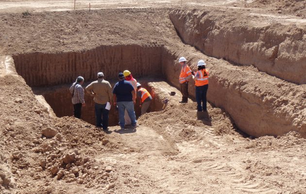
    Prior to conducting fieldwork, crew members received cultural sensitivity training through the Salt River Pima-Maricopa Indian Community to ensure that all crew members understood tribal importance of the resources they would be working to excavate. The excavations resulted in the identification and documentation of 112 features associated with the prehistoric period. One of those features was a massive, centrally located retention basin with an estimated storage capacity of 1,200 cubic meters (317,000 gallons). The reservoir is one of the largest prehistoric reservoirs documented in Arizona. It is an oval-shaped reservoir that measures approximately 38 m by 25 m with a maximum depth of approximately 7.5 m. The reservoir is associated with the late Classic Period portion of Hohokam settlement (A.D. 1375-1450) and demonstrates the inhabitants’ ability to create accessible local water sources by diverting and harvesting runoff into artificial or natural basins. The reservoir underscores the site inhabitants’ ability to successfully harvest rainfall for year-round domestic use. It operated for no more than 50 –60 years and could have supplied domestic water for up to 530 people annually.

    The ethnographic study of contemporary O’odham groups’ traditional water storage technologies, cultural views of water, technical aspects of water harvesting and storage, and related issues in the southern Arizona desert complemented the archaeological work. Logan Simpson engaged Dr. J. Andrew Darling to lead the study, and he interviewed tribal leaders and elders from the Tohono O’odham Nation and the Gila River Indian Community. Furthermore, he brought these tribal members to the excavation site to see the features unearthed by Logan Simpson’s archaeologists.

    This research on O’odham creation stories and water use has elevated archaeologists’ understanding of the persistent connections of affiliated O’odham tribes with the Sonoqui Wash Site and the Queen Creek region. Ethnographic research has also demonstrated the extent, variety, and agricultural flexibility of O’odham communities in the Queen Creek watershed. It contributes to archaeologists’ understanding of the Queen Creek delta as a series of vooshan, shallow alluviated drainages that annually wash over their banks during the summer monsoon, creating broad well-watered areas suitable for farming and water storage. Many vooshan are visible on the Tohono O’Odham reservation today, where fields and villages have been abandoned since the 1950s or earlier.

  • Teton View Regional Plan for Sustainable Development

    Residents in the rural, diverse landscape of Teton region rely on regional resources for employment, recreation, and housing—making a regional plan for sustainability and resiliency a necessity. Working together, four counties in Wyoming and Idaho created the Teton View Regional Plan for Sustainable Development. The plan highlights what the region shares in common while respecting the varied economic, political, and cultural views of each community. It presents a voluntary “livability roadmap” to guide each jurisdiction in its future development. The plan outlines parallel paths that each locality may travel independently or through coordinated, region-wide implementation. It outlines high-priority community-scale projects and multi-sector initiatives to be led voluntarily by local cities, counties, and organizations. Additional projects are summarized that may be implemented by localities over the long term. The plan’s regional approach is designed to help city and county officials, and public land managers better coordinate land-use planning, resource management, and community development efforts for the region’s long-term benefit.

    The Teton View Regional Plan for Sustainable Development earned Idaho Smart Growth’s 2016 Planning & Policy Award and the 2015 Gem Award from the Idaho Chapter of the American Planning Association.

  • West Central Mountains Economic Development Strategy

    Logan Simpson’s community planning team helped communities throughout Idaho’s West Central Mountains Region build the West Central Mountains Economic Development Strategy (WCMEDS), a plan for economic resilience. Just 10,800 residents live in the 3 million-acre region. Over the past 40 years, the area’s economy has changed dramatically. WCMEDS contains short- and long-term goals that address six elements affecting the region’s quality of life and economic future. The strategy identified five key industries for which the region is well-positioned. An adaptive management program with associated metrics allows the region’s communities to  check progress against goals.

    There has been consistent progress against the plan since its adoption, demonstrating the strong spirit of collaboration between the region’s communities. A regional economic summit has taken place; a housing trust has been established; development of a parks and recreation district is underway; and an area sector analysis project are reaching the point of completion. The group has effectively enhanced youth activities and formed partnerships to address veterans’ needs. Progress is also being made in other areas, such as workforce development, construction of bus kiosks, update of the Valley County Pathways Master Concept Plan, establishing business incubators, construction of community gardens, and forest preservation. Implementation of the plan was partially funded by two grants awarded through the America’s Best Communities (ABC) competition. The plan won the 2016 American Planning Association Vernon Deines Merit Award for an Outstanding Small Town Special Project Plan and the 2016 American Planning Association Idaho Chapter Outstanding Plan Award. Read the plan here or watch a video here.

  • Veterans Reflection Circle

    Veterans Reflection Circle honors the service of US Army Sergeant First Class Brian Mancini, who was wounded by a roadside bomb in Iraq. After he returned to his Surprise, Arizona hometown, Brian founded the nonprofit Honor House to help service men and women to make the transition back to civilian life. The memorial includes three distinct areas that tell Brian’s story. The center of the memorial represents the internal impact of Brian’s service. It features tough desert plants that surround and protect “Brian’s Bench,” a water feature that overlooks the entire memorial. An outer circle represents the community and how it surrounded Brian with support. Benches in this area allow people to pause for reflection. The “Last Walk” represents the journey only Brian could take. It connects the inner circle to the outer reaches of the reflection space and a community lake where Brian fished as a way to find healing.

    Throughout the memorial, protective concrete barriers known as Bremer walls echo the Iraqi landscape Brian experienced. The Bremer walls also provide space to display a mural about his journey, a dedication plaque, and a poem Brian wrote.

    This memorial was realized as a private-public partnership. It is located on land donated by the City of Surprise. Logan Simpson collaborated with WERK Urban Design to organize nearly 40 consultants and contractors, who donated nearly $385,000 to make the memorial a reality.

  • Chandler Fire Administration Building/Servicemen’s Memorial Plaza

    Logan Simpson’s landscape architecture team developed a comprehensive landscape and hardscape design for this Gold LEED-certified project. Site improvements included staff/visitor parking; a private staff courtyard; and street-front landscaping. The landscape architecture design features a memorial plaza between the fire administration building and the police headquarters. The plaza design merges two circles, symbolizing both departments. Integral colored concrete weaves through the circles toward two memorial sculptures. An arbor shade structure, the backbone of the plaza, helps blend the buildings’ architecture. Circular walls frame the views of the memorials, functioning as buffers and providing private seating. Colorful concrete banding designed within the paving helps to enhance the central focus of the space. A central lawn area softens the hardscape and provides an intimate feel when the plaza is not being used for large events. In addition, to meet CPTED requirements, plants stair-step back toward walls and building foundations to improve visibility. The Memorial Plaza is shared by the Chandler Fire and Police Departments and includes two memorials to the fallen local heroes who lost their lives in the line of duty and those who lost their lives in the World Trade Center attacks.

  • Block 32 Utilities Administration Building

    Located in downtown Fort Collins, Block 32 was an under-utilized parcel with potential to become a vibrant civic campus and public space. Logan Simpson worked with the architect (RNL Design) to develop programming, development concepts, and master planning for the parcel. This vision for the Civic Center is built around sustainable best practices and quality urban design standards. The design team embraced the buildings utilities’ services theme and aspired towards Net Zero classification, coordinating use of solar energy, high efficiency building materials, and low impact design planting strategies. The design incorporates the preservation of a small historic building on site with elements such as rain gardens, a living wall, and utility-themed public art formed into concrete entry walls. Construction on the two-acre Utilities Administration Building site was completed in late 2016. In June 2017, the site was awarded LEEDv4 New Construction (NC) Platinum status, the first V4 NC Platinum project in Colorado, and only the 3rd awarded in the U.S.

  • Scottsdale Airport Gateway – Hayden Road, Cactus to Redfield

    This 1.3-mile roadway segment is a gateway to Scottsdale Airport. As visitors approach the airport, they pass a series of steel “wing” sculptures representing the transition from bird wings to airplane wings. The entry plaza features the stunning sculpture Icarus Falling by Dale Wright. The surrounding hardscape features compass points  in the plaza walls and bollards and constellations used for navigation during flight cast into the ground surface.  The project was recognized by the Arizona Chapter of the American Concrete Institute in 2006 for “Unusual Use of Concrete.”  The plant palette features low-water-use, desert-adapted plants compatible with the neighborhood context. The landscape layout reflects the transition from the urban character south of the project area to the more natural desert that exists north.