• Oak Ridge State Wildlife Area Cultural Survey

    Colorado Parks & Wildlife contracted with Logan Simpson to conduct a Class III cultural resources inventories for vegetation thinning to support wildlife management activities at the Oak Ridge State Wildlife Area. The 1,535 acre project area includes 1,015 acres administered by the State of Colorado and 520 acres by the Bureau of Land Management White River Field Office in Rio Blanco County, Colorado. Services may include: prescribed burning of mountain scrub land and aspen habitats; mechanical mulching/thinning of mature mountain scrubs; clearcutting decadent aspen stands to promote regeneration of young aspen trees; interceding diverse custom seed mixes to provide diverse wildlife forage; prescribed burning as follow-up maintenance; and aerial herbicide applications to control weeds and scrub regrowth. The project is considered a federal undertaking subject to compliance with Section 106 of the National Historic Preservation Act. The inventory resulted in the recordation and evaluation of 5 prehistoric and historic sites and 7 prehistoric isolated finds.

  • Lake Powell Pipeline Biological Resource Survey

    Logan Simpson completed biological resources technical studies for the proposed 225-mile Lake Powell Pipeline. The project included the construction and operation of a buried water pipeline, water intake facility at Lake Powell, surface water storage reservoirs, hydro-electric generation facilities, and transmission lines. The pipeline corridor included federal, state, private, and tribal lands extending from Glen Canyon Dam, Arizona to Cedar City, Utah. Logan Simpson: completed 386 miles of field surveys documenting 16 special-status plant species occurrences of over 350,000 plants; mapped the distribution of 17 species of noxious/invasive weeds; recorded 306 plant taxa; and documented 3,443 polygons representing 556 vegetation associations on 25,000 acres. As alignments shifted, we assessed which rare plants potentially occur and adjusted survey schedules to match phenology of the target plants in target areas to aid in surveys and positive identification. A geospatial database of the vegetation survey results was developed to provide the basis for impact analysis of rare plants, determine mitigation actions, and develop an invasive/noxious species management plan.

  • BIA Tribal Historic Preservation Office Training

    Throughout the US, State Historic Preservation Officers (SHPOs) assist public agencies with cultural resource preservation and compliance. In 1990, the National Park Service implemented a program through which federally recognized tribes with a reservation or tribal trust lands could establish their own Tribal Historic Preservation Officer (THPO) positions. THPOs can assume SHPO’s responsibilities on tribal lands, advising federal agencies on the management of cultural resources and working to preserve, maintain, and revitalize their unique cultural traditions. Qualifying tribes can take a more direct role in protecting and interpreting the cultural resources on their own tribal lands. A THPO can focus on the culture and landscape they know, making decisions that best serve their tribal community, culture, and history.

    Tribes interested in becoming a THPO are required to submit a written resolution signed by the tribe, a THPO application form, and a program plan to the NPS for review and approval. The program plan describes how the THPO will administer historic preservation functions. Through the work and relationships developed during his tenure as the Bureau of Indian Affairs Western Regional Office archaeologist understood firsthand the incredible benefits available to tribes that attain THPO status, and he wanted to assist other tribes in taking steps to becoming a THPO.  To facilitate the process, The THPO with the Reno-Sparks Indian Colony THPO and the program manager for the NPS THPO program were recruited to conceptualize a workshop to assist tribes with completing their THPO application packets. The BIA called on Logan Simpson, bringing in archaeologists to help develop and organize the workshop. The plan was both ambitious and brilliant.

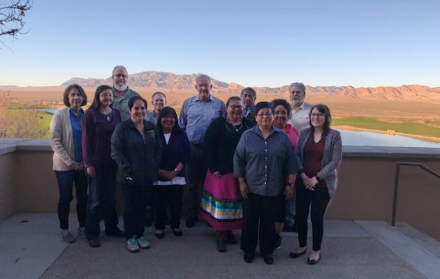
    In March of 2020, this team was able to offer interested tribes a three-day workshop at the Las Vegas Paiute Golf Resort in Nevada, with expenses associated with the workshop covered by the BIA. Four Nevada tribes were able to attend: Confederated Tribes of the Goshute Reservation; Fallon Paiute-Shoshone Tribe; Moapa Band of Paiute Indians; and Walker River Paiute Tribe. The workshop was a tremendous success. The Reno-Sparks Indian Colony THPO lent tremendous insight; the BIA Western Region archaeologist discussed compliance from a federal perspective; and the BIA THPO program manager shared her knowledge of the ins and outs of the THPO application process. Logan Simpson tied all the pieces together. The BIA’s genius was not in putting together a class, per se, but in arranging a supportive environment where tribes could complete their THPO application while attending, getting all the help they needed from experts in the field.

    In the short time since the workshop, the Director of the NPS signed Tribal Historic Preservation Agreements with two of the tribes so that they could assume certain THPO duties on their tribal lands in Nevada. The NPS has now entered into 200 THPO agreements nationwide, which is an exciting milestone for the Tribal Historic Preservation Program. Word of our success in Nevada is spreading and the team is getting calls from other tribes that are interested in participating in the next workshop. Logan Simpson is proud to be a part of this unprecedented effort, and we look forward to showcasing our continued commitment to tribal sovereignty and resource preservation.

  • Browns Canyon National Monument Resource Management Plan and EIS

    Logan Simpson led preparation of the first-ever resource management plan (RMP) for the newly-created Browns Canyon National Monument in Colorado. This 21,604-acre monument is located along the upper Arkansas River and contains scenic and diverse natural resources. The monument is jointly managed by BLM and USFS and includes one of the most heavily utilized commercial boating areas in the nation. The RMP focuses on protection of resources, continued public use and enjoyment, and continuation of historic uses, such as livestock grazing.

    Logan Simpson also prepared the associated EIS for the BLM and USFS. The EIS was completed in just 434 days from the Notice of Intent to the publication of the Record of Decision in July 2020—more than a year ahead of the contracted schedule.  Logan Simpson’s planners employed multiple strategies to help keep the project moving, such as crosswalking the agencies’ vocabularies and processes. This small but important step helped improve the Interdisciplinary Team’s respect and understanding for each agency’s guidelines and reduced schedule delays and do-overs.

  • Arizona National Memorial Cemetery

    Logan Simpson provided planning, design, and construction administration for a 31,000-gravesite expansion of the only national cemetery that features a desert design theme. The cemetery included 14,000 new burial plots, 7,000 in-ground cremain sites, and a 10,000-niche columbarium. Other provided improvements included storm drainage modifications, a founder’s plaza, three committal shelters, an assembly area, a new entry road and gate, a public information center, expansion of the existing maintenance building, expansion of the internal road system, new utilities, signage, native plantings, and irrigation.  Desert planting themes include native revegetation along the project boundaries and road edges, a native garden in the larger public gathering spaces, and wash revegetation along the edges of the drainage ways and detention basins.

  • Four Forests Restoration Initiative (4FRI) Facilitation

    The Four Forest Restoration Initiative is a collaborative effort more than 20 years in the making. 4FRI is the flagship of the Forest Service’s national Collaborative Forest Landscape Restoration Program which sought to achieve the collaborative, science-based ecosystem restoration on unhealthy forest landscapes.  This project is considered one of the most massive restoration projects in the nation. Stakeholder collaboration and consensus was central, as the values of restoration are complex. Stakeholders were a broad cross-section of more than 100 organizations, including federal, state, and local government, timber industry, preservation, and environmental interest groups, and citizens. The collaborative had often been divided deeply on specific issues and struggled to achieve consensus. Within four years, the collaborative turned over five different facilitators before turning to Logan Simpson. From 2012 to 2015, Logan Simpson guided the group through several complex challenges. Where possible, we brought electronic polling and modern collaborative planning tools into the 4FRI mix. The group’s success with Logan Simpson included revised decision rules (unanimously adopted); revision of the behavior-related ground rules of the Charter; revisioning/strategic planning each year; consensus comments on a draft EIS for the first analysis area; and successful collaborative leadership leading to broad-based support for the final EIS, which has moved to implementation without litigation. Logan Simpson managed and facilitated the collaborative with steering committee calls, facilitated meetings, problem-solving and conflict resolution.

  • National Historic and Scenic Trails Methodology, Field Guide, and Training

    Logan Simpson’s landscape architects, archaeologists, historic preservationists, biologists, visual resource specialists, and recreation specialists recently worked with the BLM to develop a first-of-its-kind methodology to help inventory, assess, and monitor National Scenic and Historic Trails (NSHTs). Since National Trails often cross multiple administrative boundaries, the BLM purposefully designed the methodology so it could be used by all agencies and organizations who share management responsibilities. This integrated approach provides federal, state, and local agencies and trail organizations with a common framework as they inventory, assess, and monitor each trail’s resources, qualities, values, settings and uses.

    The National Trails Methodology considers four landscape elements―natural, scenic, historic and cultural, and recreation―and how they work together to define the nature, purposes, and uses of a trail. An interdisciplinary team made up of agency decision-makers, technical professionals in each resource area, and members of trail organizations and volunteer groups implements the methodology. Together, they determine how to study the trail—from the locations from which inventory will be conducted to how data will be collected and analyzed, and eventually to how resources will be monitored. Cross-agency participation is encouraged when trails cross jurisdictional boundaries.

    A companion Field Guide and training curriculum provide the step-by-step guidance needed to carry out the methodology. Both the Field Guide and training emphasize the use of existing programs, skill sets, and data standards whenever possible with simple checklists and a standardized monitoring form to ensure consistency across agencies. BLM anticipates that the NSHT Methodology, Field Guide, and Training will be rolled out in early 2020.

  • Desert Tortoise Surveys

    Logan Simpson conducted desert tortoise surveys and provide data and a final report to BLM for three BLM land parcels added to the Las Vegas Field Office. To comply with federal environmental laws, the LVFO tasked Logan Simpson with collecting endangered species survey data. The 5,400 acres were surveyed according to BLM and USFWS standards and protocols. Tasks included performing a project assessment using the 2009 USFWS publication key to determine survey requirements for the project area, and submit a survey plan to LVFO for review, conducting surveys during the desert tortoise active season using 2009 USFWS published protocols, and finally providing LVFO with a final report and all survey data.

  • NPS Transportation Resource Stewardship Protection Tool

    Logan Simpson is beginning Phase IV of this project, which provides a web-based decision-support system to allow NPS staff to manage natural resources within national parks. The tool allows users to aggregate and review natural resource data from multiple parks so trends can be identified. During Phase II, Logan Simpson piloted the program in ten parks in the Southeast Region. During Phase III, we improved the tool based on information gathered from interviews conducted with NPS technical specialists. The pilot testing for this phase was conducted in the Alaska Region and included nine national parks, two national forests, three national wildlife refuges, and BLM’s Eastern Recreational Management Area. In Phase IV, Logan Simpson will update the tool; update/develop support resources; and pilot the tool in the Intermountain Region.

  • Grand Staircase Escalante National Monument Visual Resource Inventory

    Logan Simpson is currently working on the final phase of the visual resource inventory (VRI) for the Grand Staircase Escalante National Monument (GSENM), located in south-central Utah. This VRI spans a study area of just less than two million acres, including all public lands with the prior GSENM boundary, as well as almost 40,000 acres of the Kanab Field Office that are located north of the monument’s boundary. The study area includes much of the Escalante River and Paria River watershed, segments of Scenic Byway 12 (Utah’s only All-American Road) and many miles of state scenic byways and back ways. It also encompasses 16 wilderness study areas, 252 miles of suitable wild and scenic river segments, and significant archaeological and historic sites, including a segment of the Old Spanish National Historic Trail, Dance Hall Rock National Historic Site, and the Hole in the Rock State Historic Trail.