• 8th Street Multiuse Path and Streetscape

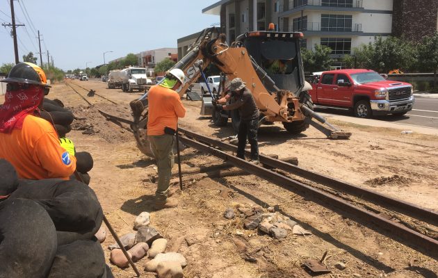
    The City of Tempe (COT) is planning construction of a multiple-use path (MUP) and streetscape improvements project along the 8th Street corridor between Rural Road and McClintock Drive. The area of potential effects (APE) is entirely situated within AZ U:9:165(ASM)/La Plaza and incorporates an alignment of AZ U:9:298(ASM)/Creamery Branch Railroad. The former is a multicomponent site that has been recommended eligible for listing in the NRHP under Criterion D (information potential) and the latter is a historic railroad that has been recommended eligible for listing in the NRHP under Criterion A (important events/history).  Logan Simpson involvement with the 8th Street MUP project was in part due to recommendation from local tribal representatives to the City to engage with a firm like Logan Simpson given the sensitivity of the resources in the project area.

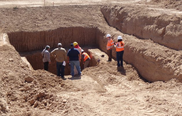
    Logan Simpson provided the COT with cultural resources services, including coordination and permitting, consultation, revision of existing Class I and Class III cultural resources reports, preparation of a Historic Properties Treatment Plan (HPTP), and execution of Phase I testing according to the HPTP. The project required project registration, an AAA project-specific permit, and burial agreement from the Arizona State Museum (ASM). Logan Simpson coordinated with the Arizona Department of Transportation (ADOT), the State Historic Preservation Office (SHPO), ASM, and COT to obtain the necessary project permits and approvals. Phase I testing consisted of 27 mechanically excavated trenches that revealed 24 prehistoric period features and 11 historic period features. These included a prehistoric human burial, pits, buried surfaces, canal segments, and structures along with historic railroad related features, buried surfaces, utilities, and irrigation ditches. Significantly, Logan Simpson archaeologists argue they discovered the remains of an exceptionally rare prehistoric Hohokam platform mound.

    Logan Simpson has worked closely with Native American tribes throughout the course of our involvement with the MUP project. We hosted a consultation meeting between the COT, ADOT, SHPO, and tribes held to discuss next steps following Phase I testing. Furthermore, we coordinated closely with the Salt River Pima-Maricopa Indian Community and other tribes to develop an addendum to the HPTP that called for close coordination with the tribe during Phase II data recovery, and our work plan includes close interaction with the tribes to ensure that this very important resource is handled in a way that is consistent with tribal values. In addition, Logan Simpson included an ethnographic study to address tribal questions in the HPTP addendum.

  • Sonoqui Wash Phase II Data Recovery


    The Town of Queen Creek requested Logan Simpson complete Phase II archaeological data recovery at site AZ U:14:49 (ASM), a prehistoric Hohokam village site also known as Los Pozos de Sonoqui, which had been determined eligible for listing in the National Register of Historic Places prior to planned construction of the Sonoqui Wash Channelization Project. The overall project’s goal was to develop and implement a plan for channelization of segments of Sonoqui Wash to improve regional flood control. The Phase II project area encompassed approximately 24 acres.

    During the planning stage of the data recovery project, Logan Simpson recommended that the Town consult with affiliated Native American tribes as our staff knew that this site was important to tribal communities. The Town agreed to consult with the tribes, and Logan Simpson included specific questions within the project’s research design in the Historic Properties Treatment Plan (HPTP) that addressed Native American perspectives on water and water management especially given that it was known that a large prehistoric reservoir was present in the project area. In their review of the HPTP, the Gila River Indian Community, Tribal Historic Preservation Office highlighted and praised Logan Simpson’s proposed plan to coordinate tribal outreach with O’odham tribal representatives and elders to obtain O’odham perspectives about the project’s archaeological findings and results.

    Prior to conducting fieldwork, crew members received cultural sensitivity training through the Salt River Pima-Maricopa Indian Community to ensure that all crew members understood tribal importance of the resources they would be working to excavate. The excavations resulted in the identification and documentation of 112 features associated with the prehistoric period. One of those features was a massive, centrally located retention basin with an estimated storage capacity of 1,200 cubic meters (317,000 gallons). The reservoir is one of the largest prehistoric reservoirs documented in Arizona. It is an oval-shaped reservoir that measures approximately 38 m by 25 m with a maximum depth of approximately 7.5 m. The reservoir is associated with the late Classic Period portion of Hohokam settlement (A.D. 1375-1450) and demonstrates the inhabitants’ ability to create accessible local water sources by diverting and harvesting runoff into artificial or natural basins. The reservoir underscores the site inhabitants’ ability to successfully harvest rainfall for year-round domestic use. It operated for no more than 50 –60 years and could have supplied domestic water for up to 530 people annually.

    The ethnographic study of contemporary O’odham groups’ traditional water storage technologies, cultural views of water, technical aspects of water harvesting and storage, and related issues in the southern Arizona desert complemented the archaeological work. Logan Simpson engaged Dr. J. Andrew Darling to lead the study, and he interviewed tribal leaders and elders from the Tohono O’odham Nation and the Gila River Indian Community. Furthermore, he brought these tribal members to the excavation site to see the features unearthed by Logan Simpson’s archaeologists.

    This research on O’odham creation stories and water use has elevated archaeologists’ understanding of the persistent connections of affiliated O’odham tribes with the Sonoqui Wash Site and the Queen Creek region. Ethnographic research has also demonstrated the extent, variety, and agricultural flexibility of O’odham communities in the Queen Creek watershed. It contributes to archaeologists’ understanding of the Queen Creek delta as a series of vooshan, shallow alluviated drainages that annually wash over their banks during the summer monsoon, creating broad well-watered areas suitable for farming and water storage. Many vooshan are visible on the Tohono O’Odham reservation today, where fields and villages have been abandoned since the 1950s or earlier.

  • Veterans Reflection Circle

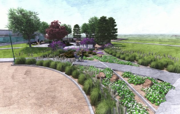
    Veterans Reflection Circle honors the service of US Army Sergeant First Class Brian Mancini, who was wounded by a roadside bomb in Iraq. After he returned to his Surprise, Arizona hometown, Brian founded the nonprofit Honor House to help service men and women to make the transition back to civilian life. The memorial includes three distinct areas that tell Brian’s story. The center of the memorial represents the internal impact of Brian’s service. It features tough desert plants that surround and protect “Brian’s Bench,” a water feature that overlooks the entire memorial. An outer circle represents the community and how it surrounded Brian with support. Benches in this area allow people to pause for reflection. The “Last Walk” represents the journey only Brian could take. It connects the inner circle to the outer reaches of the reflection space and a community lake where Brian fished as a way to find healing.

    Throughout the memorial, protective concrete barriers known as Bremer walls echo the Iraqi landscape Brian experienced. The Bremer walls also provide space to display a mural about his journey, a dedication plaque, and a poem Brian wrote.

    This memorial was realized as a private-public partnership. It is located on land donated by the City of Surprise. Logan Simpson collaborated with WERK Urban Design to organize nearly 40 consultants and contractors, who donated nearly $385,000 to make the memorial a reality.

  • Arizona National Memorial Cemetery

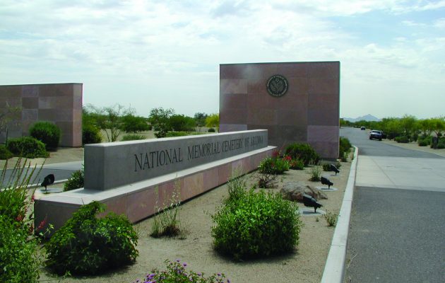
    Logan Simpson provided planning, design, and construction administration for a 31,000-gravesite expansion of the only national cemetery that features a desert design theme. The cemetery included 14,000 new burial plots, 7,000 in-ground cremain sites, and a 10,000-niche columbarium. Other provided improvements included storm drainage modifications, a founder’s plaza, three committal shelters, an assembly area, a new entry road and gate, a public information center, expansion of the existing maintenance building, expansion of the internal road system, new utilities, signage, native plantings, and irrigation.  Desert planting themes include native revegetation along the project boundaries and road edges, a native garden in the larger public gathering spaces, and wash revegetation along the edges of the drainage ways and detention basins.

  • Chandler Fire Administration Building/Servicemen’s Memorial Plaza

    Logan Simpson’s landscape architecture team developed a comprehensive landscape and hardscape design for this Gold LEED-certified project. Site improvements included staff/visitor parking; a private staff courtyard; and street-front landscaping. The landscape architecture design features a memorial plaza between the fire administration building and the police headquarters. The plaza design merges two circles, symbolizing both departments. Integral colored concrete weaves through the circles toward two memorial sculptures. An arbor shade structure, the backbone of the plaza, helps blend the buildings’ architecture. Circular walls frame the views of the memorials, functioning as buffers and providing private seating. Colorful concrete banding designed within the paving helps to enhance the central focus of the space. A central lawn area softens the hardscape and provides an intimate feel when the plaza is not being used for large events. In addition, to meet CPTED requirements, plants stair-step back toward walls and building foundations to improve visibility. The Memorial Plaza is shared by the Chandler Fire and Police Departments and includes two memorials to the fallen local heroes who lost their lives in the line of duty and those who lost their lives in the World Trade Center attacks.

  • ECO PHX

    ECO PHX is being created to meet an under-served market of environmentally conscientious residents. This purposefully sustainable, infill development of 70 apartment homes that demonstrates what is possible with today’s technology. To accomplish this objective, we approached the design process from the inside out, with sustainability components at the heart of the building’s design. The result is an economically feasible structure integrating sustainable building systems that create a distinctive residential community.


    The project integrates biomimicry by imitating the natural processes of our native Sonoran Desert: Curb cuts will bring in stormwater into the bioswales and provide a dual function of cleaning the water through vegetation as well as supplementing irrigation needs. The green wall mimics Arizona canyons and helps to cool the building. Recycled shower water from the building’s residents provides irrigation, vital in this arid climate.


    ECO PHX sets the standard for future development in Phoenix. The project is being completed for Habitat Metro and the Fenix Capital Group; team members include WERK | urban design, CCBG Architecture, Ritoch Powell, and Sletten Construction.

  • Block 32 Utilities Administration Building

    The V-shaped roofline of the “butterfly” building sets the tone for Fort Collins, Colorado’s two-block civic campus, known as Block 32. Logan Simpson worked with the architect to develop programming, development concepts, master planning, and site design for this underutilized parcel. The project was initially proposed as a design for a new Utilities Administration Building located on the block, but was expanded into a redevelopment plan for the surrounding Civic Center area as other city departments revisited their future spatial needs. The “butterfly” building was once a lab that tested products for the nearby Poudre Valley Creamery. Now a café, the building anchors the civic campus area and offers a contrast to the new, sustainably designed government buildings that surround it, including the Utilities Administration Building.

    Several concepts were developed for arranging the site, and 3-D modeling was was used so stakeholders could understand the choices and preferred design solution. The design team embraced sustainable design and is aspiring towards Net Zero classification, coordinating the use of solar energy, high efficiency building materials, and low-impact design planting strategies. The site design incorporates the preservation of a small historic building on site with elements such as rain gardens, biofiltration swales, low water landscape, a green wall, and utility themed public art formed into concrete entry walls. The site was awarded LEEDv4 New Construction (NC) Platinum status. According to the USGBC, this is the first V4 NC Platinum project in Colorado, and only the third in the U.S. In 2019, the project was awarded the City of Fort Collin Urban Design Award for Sustainable Design & Public Spaces.

  • Scottsdale Airport Gateway – Hayden Road, Cactus to Redfield

    This 1.3-mile roadway segment is a gateway to Scottsdale Airport. As visitors approach the airport, they pass a series of steel “wing” sculptures representing the transition from bird wings to airplane wings. The entry plaza features the stunning sculpture Icarus Falling by Dale Wright. The surrounding hardscape features compass points  in the plaza walls and bollards and constellations used for navigation during flight cast into the ground surface.  The project was recognized by the Arizona Chapter of the American Concrete Institute in 2006 for “Unusual Use of Concrete.”  The plant palette features low-water-use, desert-adapted plants compatible with the neighborhood context. The landscape layout reflects the transition from the urban character south of the project area to the more natural desert that exists north.

  • Standin’ on the Corner Park, Performance Plaza, and Downtown Streetscape

    Thirty years after Interstate 40 bypassed historic Route 66 through Winslow, Arizona, the town took on a project to restore the historic character of its downtown core, which is largely defined by its relationship to the roadway. Improvements included Standin’ on the Corner Park, named for the Eagles song “Take it Easy,” which includes the lyrics “I’m standin’ on the corner in Winslow, Arizona/And such a fine sight to see/It’s a girl, my lord, in a flatbed Ford/Slowin’ down to take a look at me.” Under a Transportation Enhancement grant, Logan Simpson designed the park, an ADA accessible performance stage using historic car front ends as for lighting, a stage cover, and provided theming and streetscape design for the sidewalk trellis, perimeter sidewalk areas, including landscape, accent paving, and street furnishings.

  • Community Wildfire Protection Plans

     The wildland urban interface (WUI) is the area where homes are built near or among lands prone to wildland fire. These areas have become more popular for homeowners for their privacy, natural beauty, recreational opportunities and affordable living. As a result, rural fire districts are more often having to fight fire and protect homes and property within these WUI areas. Logan Simpson developed the first two CWPPs in Arizona for the at-risk communities of the Apache-Sitgreaves National Forest that complied with Title I of the Healthy Forests Restoration Act of 2003 (HFRA). We facilitated the collaboration among Federal, state, and local partners as well as Native American tribes to developed these two CWPPs and established priorities to reduce the risks to communities and surrounding lands. Subsequent to these first two CWPPs, Logan Simpson developed 20 CWPPs, analyzed over 31 million acres, and gathered input from over 300 communities across multiple states.