• Uniquely Driggs Comprehensive Plan, Idaho

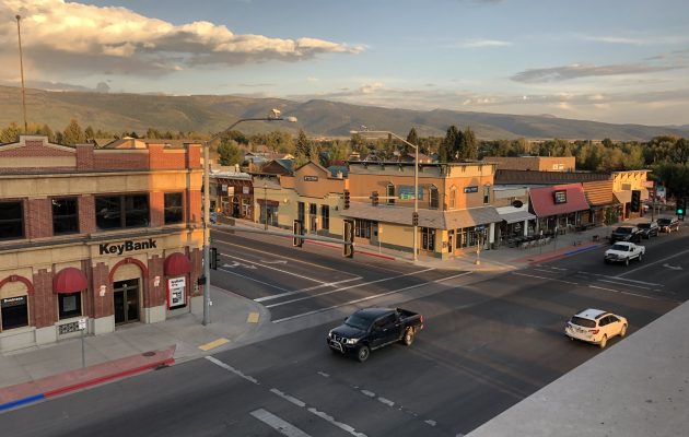
    Located between the Tetons and the Big Hole Mountains, Driggs has a thriving community of 1,800 residents. Logan Simpson developed a comprehensive plan update with a primary focus on health, with opportunities to improve health in the built environment integrated in to every element of the document. The boom and bust tourism economy has impacted Driggs since the 2008 recession, which led to several platted and unbuilt lots resulting in a housing shortage.  Logan Simpson and our team of consultants took a targeted approach to reviewing multiple housing program options to find solutions for workforce housing and supporting a balanced economy.

    As an inter-city airport, the land use component of the plan needed to take into account all of the ITD requirements in regard to crash and transition zones. Close coordination with the Driggs Airport Board was necessary to ensure compliance with applicable regulations, and to ensure continued operation and expansion of airport operations and associated industry, as residential uses continue to encroach upon the boundary. The Airport Master Plan was completed by the Board, and in tandem with the Comprehensive Plan in order to ensure consistency in these regulations and vision.

    Incorporation of health metrics and a focus on dedicated Hispanic outreach for the Uniquely Driggs Comprehensive Plan helped the project to win a 2020 Western Planner Rural Innovation Award. Outreach to minority communities were a focus of the plan. Through bilingual outreach materials, working with the Hispanic Resource Center, and meeting with middle and high school students, the project team proved to be highly successful in reaching the historically under-represented population.

    WINNER of the 2020 Western Planner – Rural Innovation Award

    The Plan highlighted the thoughtful housing approaches, pragmatic focus on infill, and sensitivity to critical habitats and neighboring jurisdictions. “It’s a plan that I will examine to provide ideas to other communities I work with and in addition I appreciate the thoughtful approaches for a beautiful place.” – Paul Mobley, AICP, PCED, The Western Planner

  • South of the River Subarea Plan

    The South of the River Subarea Plan presents a unique opportunity to support desired development patterns featuring a riverfront mixed-use activity center, surrounded by varied residential densities and connected by thoughtfully designed roads, trails, and paths. This detailed process includes a subarea plan and a detailed conceptual plan for a mixed-use activity center, vetted through stakeholder, and public engagement, traffic modelling, and floodplain analysis to ensure feasible and development that matches the intent and purpose of the subarea. The final plan will include a detailed subarea plan with illustrative sketches, visual simulations, and a strategic implementation guide. In addition, the Logan Simpson team will develop code overlay and text modification recommendations to ensure realization of the vision from the subarea plan.

    The subarea plan will provide a higher level of detail than the Com­prehensive Plan could, with specific detail for development at Star Road and along the Boise River in order to plan this area as the new downtown for Star.

  • Pagosa Springs Land Use Development Code Update

    The Logan Simpson team is working with the Town of Pagosa Springs to update the Pagosa Springs Land Use Development Code (LUDC). Pagosa Springs has experienced an uptick in growth over the past five years growing from approximately 1,800 residents in 2015 to 2,147 in 2020. With a well-established downtown, medical center, regional airstrip, outdoor recreation, and the popular hot springs, Pagosa Springs is quickly becoming a desirable place for people and businesses to establish. In order to continue to encourage development in a way that is respectful of the community vision as set forth in Pagosa Springs Forward, Comprehensive Plan, the current Land Use Development Code (LUDC) is being updated to streamline application processes and better address housing attainability, short term rental impacts, parking, environmental protections, and general design standards throughout the code. Additional topics up for discussion include stormwater management, solar priorities, electric vehicle charging, and low water landscaping.

  • Ketchum Historic Preservation Plan Update

    Logan Simpson worked diligently with City Staff to expedite drafting of an interim historic preservation ordinance to enact baseline regulations and protections while a permanent ordinance with incentives and design guidelines is developed. The interim ordinance was developed with the input of many community stakeholders – including historians, developers, architects, real estate agents, and members of the community – through online surveys and small group meetings. Logan Simpson is currently working with the City of Ketchum to develop a permanent historic preservation ordinance, historic design guidelines, and a preservation handbook with preservation incentives.

  • Jackson Teton County Growth Management Plan

    Logan Simpson worked with the Town of Jackson and Teton County on the Growth Management Program (GMP) Review and an update to the forward-thinking 2012 Comprehensive Plan, previously completed by Logan Simpson staff Bruce Meighen and Megan Moore. The area is located on the edge of Yellowstone and includes the Town of Jackson and many smaller communities. The GMP Review was an in-depth statistical and community-based check-in on how the plan has been functioning over the last seven years and allows the team to systematically revise the plan through the identification of corrective actions necessary to better implement its vision. For this update, tasks have included an overall audit of the plan, using a three-tiered priority rating system based on seven years of indicator data, trend analysis, and an outreach campaign to understand the community’s perception. Looking back, the Plan shifted growth from rural areas into complete neighborhoods (over 60% into complete neighborhoods) and resulted in thousands of units of new workforce housing (over 65% of people who work in Jackson/Teton live there). Our work developing the Character Districts, Code, and Housing Action Plan has ensured growth is directed to the correct places. Fundamental changes to the Plan will be a limit on greenhouse gases, no new single-occupancy lane miles constructed, and an environmental keystone indicator. The Plan update process can be found at http://www.jacksontetonplan.com/315/Growth-Management-Program-GMP-Review-Upd, and the overall plan is located at http://www.jacksontetonplan.com/270/Comprehensive-Plan.

  • Teton View Regional Plan for Sustainable Development

    Residents in the rural, diverse landscape of Teton region rely on regional resources for employment, recreation, and housing—making a regional plan for sustainability and resiliency a necessity. Working together, four counties in Wyoming and Idaho created the Teton View Regional Plan for Sustainable Development. The plan highlights what the region shares in common while respecting the varied economic, political, and cultural views of each community. It presents a voluntary “livability roadmap” to guide each jurisdiction in its future development. The plan outlines parallel paths that each locality may travel independently or through coordinated, region-wide implementation. It outlines high-priority community-scale projects and multi-sector initiatives to be led voluntarily by local cities, counties, and organizations. Additional projects are summarized that may be implemented by localities over the long term. The plan’s regional approach is designed to help city and county officials, and public land managers better coordinate land-use planning, resource management, and community development efforts for the region’s long-term benefit.

    The Teton View Regional Plan for Sustainable Development earned Idaho Smart Growth’s 2016 Planning & Policy Award and the 2015 Gem Award from the Idaho Chapter of the American Planning Association.

  • West Central Mountains Economic Development Strategy

    Logan Simpson’s community planning team helped communities throughout Idaho’s West Central Mountains Region build the West Central Mountains Economic Development Strategy (WCMEDS), a plan for economic resilience. Just 10,800 residents live in the 3 million-acre region. Over the past 40 years, the area’s economy has changed dramatically. WCMEDS contains short- and long-term goals that address six elements affecting the region’s quality of life and economic future. The strategy identified five key industries for which the region is well-positioned. An adaptive management program with associated metrics allows the region’s communities to  check progress against goals.

    There has been consistent progress against the plan since its adoption, demonstrating the strong spirit of collaboration between the region’s communities. A regional economic summit has taken place; a housing trust has been established; development of a parks and recreation district is underway; and an area sector analysis project are reaching the point of completion. The group has effectively enhanced youth activities and formed partnerships to address veterans’ needs. Progress is also being made in other areas, such as workforce development, construction of bus kiosks, update of the Valley County Pathways Master Concept Plan, establishing business incubators, construction of community gardens, and forest preservation. Implementation of the plan was partially funded by two grants awarded through the America’s Best Communities (ABC) competition. The plan won the 2016 American Planning Association Vernon Deines Merit Award for an Outstanding Small Town Special Project Plan and the 2016 American Planning Association Idaho Chapter Outstanding Plan Award. Read the plan here or watch a video here.

  • Larimer County Comprehensive Plan and Mountain Resilience Plan

    No community is immune from the impacts of significant disruptions, and it is impossible to anticipate and prepare for all possible natural or economic hazard events. Larimer County’s new Comprehensive Plan helps build individual and community self-sufficiency in the event of a disaster, as well as strengthening the capacity of the county to continue supplying critical goods and services during emergency situations and throughout recovery.

    Larimer County is diverse—demographically, economically and geographically. More than half of the County’s 2,634 square miles is sparsely populated mountainous terrain, while the Front Range area encompasses one of the fastest growing urban areas in Colorado. Larimer County recognized the areas’ different challenges, and elected to develop the new comprehensive plan into two phases, each of which address the needs of the mountain and Front Range communities separately.

    The Comprehensive Plan holistically structured the format, process, and content around six resiliency frameworks: community, economy, health & social, housing, infrastructure, and watersheds & natural resources. Public involvement was key to the Plan’s success, and the plan was refined through in-person conversations at 13 community events, 830 online survey responses, 46 one-on-one interviews, and over 25 regular workshops with the three project committees and county leaders.

    The Plan in Action

    An unexpected and favorable result of the two-phase approach was early implementation and actions even ahead of adoption of the full Comprehensive Plan. The Framework Map geographically illustrates the policies reflected in the plan, including subarea planning and targeted rural development. Other notable achievements since plan adoption include the current update of the County Land Use Code to reflect the community’s vision and moving forward on establishing a process and prioritization criteria for subarea planning for unincorporated communities.

    The Comprehensive Plan called for expansion of broadband service into digitally isolated rural areas, as well as the expansion of the Larimer Connects program—a county program created with the understanding that communities that do not have good social connectivity and access to resources are not able to fulfill their potential in becoming resilient. These programs are already proving to be essential to managing the impacts of the COVID-19 pandemic on rural residents.

    The Larimer County Comprehensive Plan and Mountain Resilience Plan won the 2020 Community Resiliency Honor Award from the Colorado Chapter of the American Planning Association. Read the plan here. 

  • Green Mountain Falls Comprehensive Plan & Hazard Resiliency


    Logan Simpson worked with the Town of Green Mountain Falls to update their Comprehensive Plan. GMF is a small mountainous community challenged by the recession, wildfires, small landslides, and flooding. Still the community maintains successful businesses and public amenities, due in large part to a supportive community of committed residents and volunteers and a unique town character and extensive trails system that draws visitors from near and far. This plan recommended tailored and actionable direction based on key issues and opportunities. It established a basis for future Town policies and priorities for development and will provide a balanced, predictable, and flexible land use plan and implementable strategies for housing affordability, hazard mitigation and resilience, infrastructure upgrades, and general improvements for community services and character. In regards to resiliency, the plan analyzed wildfire and its effect on this wildland-urban interface community. Land use policies to protect critical human infrastructure, municipal water and power supplies, evacuation routes, and major recreation areas and transportation corridors were then developed. The plan was unanimously adopted in July 2019. Read it here.

  • Our Big Sky Community Vision & Strategy

    Logan Simpson is working with the community of Big Sky, Montana to develop a cohesive vision and implementation strategy for future development, capital improvement projects, and strategic investments. Big Sky finds itself at an intersection–it is transitioning from a resort to a community. Logan Simpson is tasked to answer the following question: “What will Big Sky look like in 10 years?”

    The plan’s foundation identified and articulated the vision and goals that emerged from a robust public outreach process that represented Big Sky as a whole. Stakeholders demonstrated their support and a commitment early in the planning process; therefore, Logan Simpson focused on encouraging engagement from those not already involved–the locals. It was clear a hands-on approach was needed since many were hesitant to participate because they have worked in the community for only a short time, were too busy to participate, or did not want to disrupt their employment status. By offering one-on-one interviews (which broke our records for participation), our goal was to show the local workforce and permanent residents that they represent and reinforce the culture of Big Sky, and that their input truly does matter.

    We learned everyone comes from somewhere else in Big Sky—and have pride in choosing this great place. Likewise, everyone cares deeply about its future. Key issues identified during the initial outreach include infrastructure, road improvements, attainable housing, community gathering areas, and protection of the rivers. It was rewarding to learn that the values of all–the locals, landowners, developers, community leaders, and elected officials–are aligned by the desire to grow environmentally, socially, and economically. The plan will impact interagency collaboration and refocus efforts to address current issues and future opportunities. View the plan here.